Kosi Zone
Appearance
This article relies largely or entirely on a single source. (January 2021) |
Kosi
कोसी अञ्चल[1] कोशी अञ्चल | |
|---|---|
 | |
| Country | |
| Named for | Koshi River |
| Districts | |
| Area | |
• Total | 9,669 km2 (3,733 sq mi) |
| Population (2011) | |
• Total | 2,335,047 |
| • Density | 240/km2 (630/sq mi) |
| Time zone | UTC+5:45 (Nepal Time) |
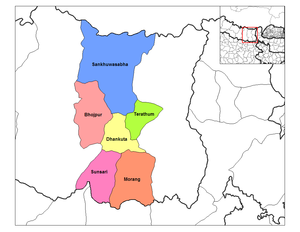
Kosi or Koshi (Template:Lang-ne, Template:Lang-ne ) was one of the fourteen zones of Nepal until the restructure of zones to provinces. The headquarters of Kosi Zone was Biratnagar which was also its largest city. Other cities of Kosi Zone were Inaruwa, Dharan, Dhankuta, Jhumka, Duhabi, Tarahara and Itahari. Its main rivers were Arun, Tamor and Sapta Koshi.
Administrative subdivisions
Kosi was divided into six districts; since 2015 these districts have been redesignated as part of Province No. 1.
| District | Type | Headquarters | Since 2015 part of Province |
|---|---|---|---|
| Bhojpur | Hill | Bhojpur | Province No. 1 |
| Dhankuta | Hill | Dhankuta | |
| Morang | Terai | Biratnagar | |
| Sankhuwasabha | Mountain | Khandbari | |
| Sunsari | Terai | Inaruwa | |
| Terhathum | Hill | Myanglung |
Famous and religious places
- Pindeswari Temple, Dharan
- Budha Subba Temple, Dharan
- Panchakanya Temple, Dharan
- Bishnupaduka Temple, Dharan
- Kali Mandir, Biratnagar
- Chintaangdevi Temple, Dhankuta
- Namaste Jharana, Vedetar
- Ramdhuni Mandir, Dhuni Ban
- Jhumkeshwar Mahadev, Jhumka
- Barahkshetra Mandir Barahachhetra
- Auliya Baba Mandir, Chatara
- Jabdi Mata Mandir, Pakali
- Betana Shimsar, Belbari[citation needed]
- Durgadevi Mandir, Laukahi
See also
- Development Regions of Nepal (Former)
- List of zones of Nepal (Former)
- List of districts of Nepal
References
- ^ "कोसी". नेपाली बृहत शब्दकोश (in Nepali). Kathmandu: Nepal Academy.
