Bobigny–Pablo Picasso station
Bobigny–Pablo Picasso Préfecture–Hôtel du Département | |||||||||||
|---|---|---|---|---|---|---|---|---|---|---|---|
 MF 01 rolling stock at Bobigny–Pablo Picasso in 2022 | |||||||||||
| General information | |||||||||||
| Location | Rue Pablo Picasso × Boul. Maurice Thorez Trésorerie Générale de la Seine–Saint-Denis Gare Routière Bobigny — Pablo Picasso (five) Bobigny Île-de-France France | ||||||||||
| Coordinates | 48°54′24″N 2°27′00″E / 48.906538°N 2.449994°E | ||||||||||
| Owned by | RATP | ||||||||||
| Operated by | RATP | ||||||||||
| Line(s) | |||||||||||
| Platforms | 2 (1 island platform, 1 side platform) | ||||||||||
| Tracks | 3 | ||||||||||
| Other information | |||||||||||
| Station code | 0312 | ||||||||||
| Fare zone | 1 | ||||||||||
| History | |||||||||||
| Opened | 25 April 1985 | ||||||||||
| Passengers | |||||||||||
| 4,752,569 (2020) | |||||||||||
| Services | |||||||||||
| |||||||||||
| |||||||||||
Bobigny–Pablo Picasso (French pronunciation: [bɔbiɲi pablo pikaso]) is the northern terminus of Line 5 of the Paris Métro, as well as a stop on Île-de-France tramway Line 1. Also, it will be a station on Paris Metro Line 15 in the future. The metro station was opened in 1985, followed by the tram stop seven years later.
The name refers to the commune of Bobigny and to Rue Pablo Picasso, named after the Spanish modern artist Pablo Picasso. In 2013, the station was used by 7,135,266 passengers, which makes it the 38th busiest of the Métro network, out of 302 stations.[1]
In 2020, the station was used by 4,752,569 passengers amidst the COVID-19 pandemic, making it the 20th busiest of the Métro network, out of 305 stations.[2]
Passenger services
[edit]Access
[edit]The station has 4 entrances:
- Access 1: Hôtel de Ville
- Access 2: Palais de Justice
- Access 3: Rue Carnot
- Access 4: Prefecture
Station layout
[edit]| Street Level |
| B1 | Mezzanine |
| Line 5 platforms | Southbound | ← |
| Island platform, doors will open on the left, right | ||
| Southbound | ← | |
| Northbound | | |
| Side platform, doors will open on the right | ||
Platforms
[edit]The station has, as does Porte de Pantin located on the same line, a particular arrangement specific to the stations serving or had served as a terminus. It has three tracks and two platforms. The side platform serves as the arrival platform while the island platform serves as the departure platform. The walls are flush with the platforms and are vertical, with the roof of the station being straight without metal panels, unlike other stations on the network.
A turnback exists 160 meters beyond the station under the rue Pablo-Picasso to allow for trains to reverse due to its role as the terminus.
Other connections
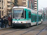
[edit]Since 6 July 1992, the station has been served by tramway T1, and before the extension to Noisy-le-Sec station on 15 December 2003, was its eastern terminus.
A bus station is located above the station and offers connections with lines 146, 148, 234, 251, 301, 303 and 322 of the RATP Bus Network, with lines 615 and 620 of the Transdev TRA bus network, with line 93 of the CIF bus network, with line 8 of the Trans Val de France bus network and, at night, with lines N13, N41, and N45 of the Noctilien network.
Gallery
[edit]-
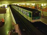
MF 67 rolling stock at Bobigny–Pablo Picasso
-
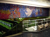
Artwork at Bobigny–Pablo Picasso
-
T1 tram at Bobigny–Pablo Picasso
-
T1 tram at Bobigny–Pablo Picasso

References
[edit]- ^ (in French) Trafic annuel entrant par station (2013) Archived 2013-03-08 at the Wayback Machine, sur le site data.ratp.fr (consulté le 31 août 2014).
- ^ "Trafic annuel entrant par station du réseau ferré 2020". data.ratp.fr (in French). Retrieved 2022-01-20.
- Roland, Gérard (2003). Stations de métro. D'Abbesses à Wagram. Éditions Bonneton.


