Cova Lima Municipality
You can help expand this article with text translated from the corresponding article in German. (July 2011) Click [show] for important translation instructions.
|
This article needs additional citations for verification. (February 2017) |
Cova Lima | |
|---|---|
| |
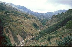
 Mountain area in Cova Lima | |
 | |
| Coordinates: 9°19′S 125°15′E / 9.317°S 125.250°E | |
| Country | |
| Capital | Suai |
| Administrative posts | |
| Area | |
• Total | 1,198.6 km2 (462.8 sq mi) |
| • Rank | 7th |
| Population (2015 census) | |
• Total | 65,301 |
| • Rank | 9th |
| • Density | 54/km2 (140/sq mi) |
| • Rank | 9th |
| Households (2015 census) | |
| • Total | 12,564 |
| • Rank | 8th |
| Time zone | UTC+09:00 (TLT) |
| ISO 3166 code | TL-CO |
| HDI (2017) | 0.618[1] medium · 3rd |
| Website | Cova Lima Municipality |
Cova Lima (Portuguese: Município Cova Lima, Tetum: Munisípiu Kovalima) is a municipality of East Timor, in the Southwest part of the country. It has a population of 59,455 (Census 2010) and an area of 1,230 km2.[2] The capital of the municipality is Suai, which lies 136 km from Dili, the national capital.[3]
Etymology
[edit]There are two different explanations for the municipality's name. First, it could be derived from koba (a basket used for ritual acts) and lima, the Tetum word for 'five'. The combination is said to represent either the five mythical daughters of the Liurai (traditional title of a Timorese ruler) of Fohorem Nutetu,[4]: 5 [5] or five kingdoms consisting of Fatumea, Dakolo, Lookeu, Sisi and Maudemi.[5][6]
According to a second explanation, the English language name of the municipality is said to be a Portuguese approximation of the words kaua lima or portmanteau Kaualima, which means 'five crows' in Tetum.[7][8]
It has been asserted that the Portuguese version of the name, perhaps intentionally, has a symbolically derogatory meaning, namely 'Five Graves' or 'Five Holes', as the Portuguese word cova means 'grave' or 'hole'. According to that assertion, the Portuguese version may also be a "... form of cultural and mind de-colonization ..." [sic - colonization] of the local name.[6]
Geography
[edit]Cova Lima borders the Timor Sea to the south, the municipalities of Bobonaro to the north, Ainaro to the east, and the Indonesian province of East Nusa Tenggara to the west.
Administrative posts
[edit]The administrative posts of Cova Lima are Fatululic, Fatumean, Fohorem, Zumalai, Maucatar, Suai, and Tilomar.[9]
References
[edit]Notes
[edit]- ^ "Sub-national HDI - Area Database - Global Data Lab". hdi.globaldatalab.org. Retrieved 13 September 2018.
- ^ "Friends of Suai/Covalima" (PDF). City of Port Phillip. May 2014. Archived from the original (PDF) on 25 March 2016. Retrieved 22 February 2017.
- ^ "Friends of Suai: Strategic Plan: 2010 to 2020" (PDF). City of Port Phillip. Archived from the original (PDF) on 1 April 2016. Retrieved 22 February 2017.
- ^ District Profile Covalima (PDF) (Report). April 2002. Archived from the original (PDF) on 14 October 2013. Retrieved 26 April 2022.
- ^ a b "Perfil: 2. Toponímia" [Profile: 2. Toponymy]. Cova Lima Municipality (in Tetum). Retrieved 18 July 2022.
- ^ a b "The Real Political and Cultural Meaning and Short History of Koba Lima and Suai". Suai Media Space. Retrieved 26 April 2022.
- ^ Hull, Geoffrey (June 2006). "The placenames of East Timor" (PDF). Placenames Australia: Newsletter of the Australian National Placenames Survey: 6–7, at 7. Archived (PDF) from the original on 13 July 2018. Retrieved 25 April 2022.
- ^ Morris, Cliff (1984). Tetun - English Dictionary (PDF). Pacific Linguistics Series C - No. 83. Canberra: Department of Linguistics, Research School of Pacific Studies, Australian National University. pp. 104, 131. ISBN 0858833085.
- ^ Gunn, Geoffrey C (2011). Historical Dictionary of East Timor. Lanham, Maryland: Scarecrow Press. p. 67. ISBN 9780810867543.
Bibliography
[edit]- Barrkman, Joanna (2014). The Textiles of Covalima, Timor-Leste. Dili: Governo de Timor-Leste. ISBN 9789898726261. Retrieved 26 October 2018.
- Munisipio Covalima: Planu Estartejiku Desenvolvimentu Munisipal [Cova Lima Municipality: Municipal Strategic Development Plan] (Report) (in Tetum). Ministry of State Administration (East Timor) / Administration of Cova Lima Municipality. 2015. Retrieved 18 July 2022.
- Perfil Distritu Covalima [Cova Lima District Profile] (PDF) (Report) (in Tetum). 2012. Archived (PDF) from the original on 3 March 2014. Retrieved 18 July 2022.
External links
[edit]![]() Media related to Cova Lima (Municipality) at Wikimedia Commons
Media related to Cova Lima (Municipality) at Wikimedia Commons
- Cova Lima Municipality – official site (in Tetum with some content in English)
- Cova Lima Municipality – information page on Ministry of State Administration site (in Portuguese and Tetum)


