Dominion City
This article needs additional citations for verification. (January 2021) |
Dominion City | |
|---|---|
 Dominion City in 2006. | |
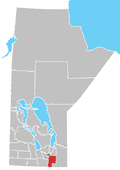
Location of Dominion City in Manitoba | |
| Coordinates: 49°08′31″N 97°09′20″W / 49.14194°N 97.15556°W | |
| Country | Canada |
| Province | Manitoba |
| Region | Eastman |
| Rural Municipality | Emerson-Franklin |
| Established | 1874 |
| Government | |
| • Governing body | Municipality of Emerson-Franklin |
| • MP (Provencher) | Ted Falk (CPC) |
| • MLA (La Verendrye) | Konrad Narth (PC) |
| Area | |
• Total | 2.56 km2 (0.99 sq mi) |
| Population | |
• Total | 319 |
| • Density | 124.4/km2 (322/sq mi) |
| Time zone | UTC-6 (CST) |
| • Summer (DST) | UTC-5 (CDT) |
| Postal Code | R0A 0H0 |
Dominion City is an unincorporated community in the Municipality of Emerson – Franklin, Manitoba Canada. It is located in southeastern part of the province, approximately 20 kilometres (12 miles) north of the Canada–United States border.
Dominion City is served by Roseau Valley School. The community also has a pool, a museum, a bank, a credit union, a general store, a hockey rink, a curling club, and a nine-hole golf course. Historic buildings in Dominion City include All Saints Anglican Church, which is now used as the Franklin Museum.
The original name of the community was Roseau, later Roseau Crossing. It changed to the current name in 1878 to avoid confusion with similarly-named communities, such as Roseau, Minnesota. The "City" was added in keeping with Crystal City and Rapid City.[further explanation needed][1] The post office was called Roseau Crossing upon establishment in 1876 and renamed Dominion City in 1880.
Demographics
[edit]In the 2021 Census of Population conducted by Statistics Canada, Dominion City had a population of 319 living in 148 of its 187 total private dwellings, a change of -9.6% from its 2016 population of 353. With a land area of 2.56 km2 (0.99 sq mi), it had a population density of 124.6/km2 (322.7/sq mi) in 2021.[2]
Notable people
[edit]- Jacob Anderson, priest
- Buddy Knox, 1950s rock and roll star[3]
- Julie Masi, musician, member of The Parachute Club[4]
- Denton Mateychuk, ice hockey player
References
[edit]- ^ Hamilton, William (1978). The Macmillan Book of Canadian Place Names. Toronto: Macmillan. p. 58. ISBN 0-7715-9754-1.
- ^ "Population and dwelling counts: Canada and designated places". Statistics Canada. February 9, 2022. Retrieved September 3, 2022.
- ^ "Rockabilly star put down Manitoba roots". Winnipeg Free Press. August 20, 2016. Retrieved June 2, 2021.
- ^ John Einarson, Soaring with Parachute Club: Singer pulled rip cord on music career after success in the '80s. Winnipeg Free Press, October 19, 2014. Retrieved 2016-12-10.
- Geographic Names of Manitoba (pg. 65) - the Millennium Bureau of Canada


