
File:1771 Bonne Map of Alsace and Lorraine, France - Geographicus - AlsaceLorraine-bonne-1771.jpg

Size of this preview: 800 × 584 pixels. Other resolutions: 320 × 234 pixels | 640 × 467 pixels | 1,024 × 747 pixels | 1,280 × 934 pixels | 2,560 × 1,868 pixels | 3,500 × 2,554 pixels.
Original file (3,500 × 2,554 pixels, file size: 2.69 MB, MIME type: image/jpeg)
| This is a file from the Wikimedia Commons. Information from its description page there is shown below. Commons is a freely licensed media file repository. You can help. |
Summary
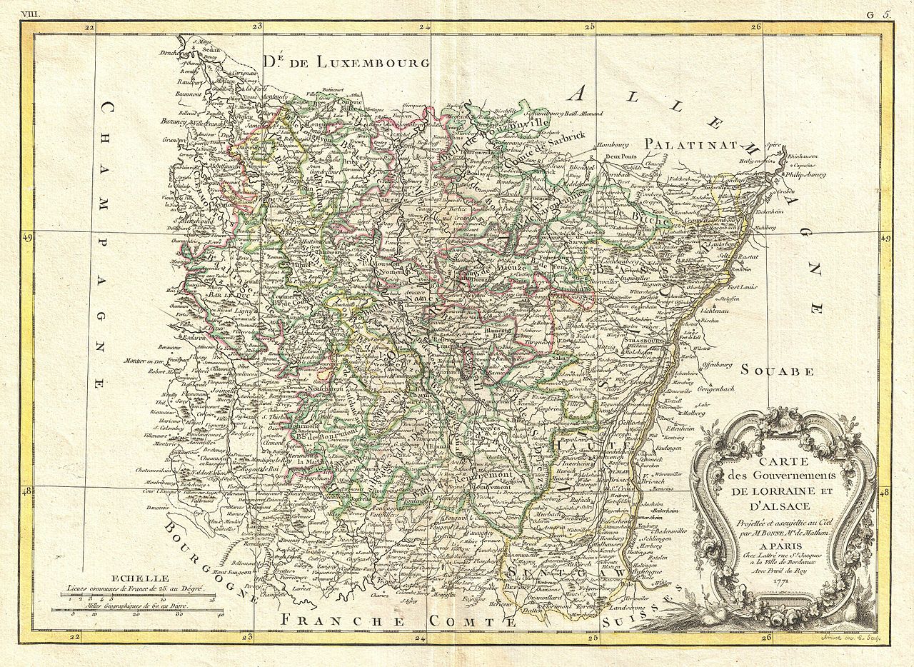
| Rigobert Bonne: Carte des Gouvernements de Lorraine et D'Alsace.
( |
|||||||||||||||||||||||
|---|---|---|---|---|---|---|---|---|---|---|---|---|---|---|---|---|---|---|---|---|---|---|---|
| Artist |
|
||||||||||||||||||||||
| Title |
Carte des Gouvernements de Lorraine et D'Alsace. |
||||||||||||||||||||||
| Description |
English: A beautiful example of Rigobert Bonne's decorative map of the French winemaking regions of Alsace and Lorraine. Covers from Champagne east to Souabe, north to Luxembourg, and south to Switzerland. This region, which traded hands several times between France and Germany, is known for its exceptional cuisine, wines, and unique culture. A large decorative title cartouche appears in the lower right quadrant. Drawn by R. Bonne in 1771 for issue as plate no. G 5 in Jean Lattre's 1776 issue of the Atlas Moderne . |
||||||||||||||||||||||
| Date | 1771 (undated) | ||||||||||||||||||||||
| Dimensions | height: 13 in (33 cm); width: 17.5 in (44.4 cm) | ||||||||||||||||||||||
| Accession number |
Geographicus link: AlsaceLorraine-bonne-1771 |
||||||||||||||||||||||
| Source/Photographer |
Lattre, Jean, Atlas Moderne ou Collection de Cartes sur Toutes les Parties du Globe Terrestre, c. 1775.
|
||||||||||||||||||||||
Licensing
|
This is a faithful photographic reproduction of a two-dimensional, public domain work of art. The work of art itself is in the public domain for the following reason:
The official position taken by the Wikimedia Foundation is that "faithful reproductions of two-dimensional public domain works of art are public domain".
This photographic reproduction is therefore also considered to be in the public domain in the United States. In other jurisdictions, re-use of this content may be restricted; see Reuse of PD-Art photographs for details. | ||||
File history
Click on a date/time to view the file as it appeared at that time.
| Date/Time | Thumbnail | Dimensions | User | Comment | |
|---|---|---|---|---|---|
| current | 17:35, 23 March 2011 | | 3,500 × 2,554 (2.69 MB) | BotMultichillT | {{subst:User:Multichill/Geographicus |link=http://www.geographicus.com/P/AntiqueMap/AlsaceLorraine-bonne-1771 |product_name=1771 Bonne Map of Alsace and Lorraine, France |map_title=Carte des Gouvernements de Lorraine et D'Alsace. |description=A beautiful |
File usage
The following pages on the English Wikipedia use this file (pages on other projects are not listed):