
File:Arrondissement Roeselare Belgium Map.png
No higher resolution available.
Arrondissement_Roeselare_Belgium_Map.png (270 × 203 pixels, file size: 5 KB, MIME type: image/png)
| This is a file from the Wikimedia Commons. Information from its description page there is shown below. Commons is a freely licensed media file repository. You can help. |

|
File:Arrondissement Roeselare Belgium Map.svg is a vector version of this file. It should be used in place of this PNG file when not inferior.
File:Arrondissement Roeselare Belgium Map.png → File:Arrondissement Roeselare Belgium Map.svg
For more information, see Help:SVG. |
 |
Summary
| Description |
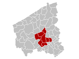
Brezhoneg: Arondisamant Roeselare, Belgia.
English: Location of Arrondissement Roeselare in Belgium. |
| Source | Own work |
| Author | Westermarck |
from nl:wiki
Licensing

|
Permission is granted to copy, distribute and/or modify this document under the terms of the GNU Free Documentation License, Version 1.2 or any later version published by the Free Software Foundation; with no Invariant Sections, no Front-Cover Texts, and no Back-Cover Texts. A copy of the license is included in the section entitled GNU Free Documentation License. |
| This file is licensed under the Creative Commons Attribution-Share Alike 3.0 Unported license. | ||
| ||
| This licensing tag was added to this file as part of the GFDL licensing update. |
File history
Click on a date/time to view the file as it appeared at that time.
| Date/Time | Thumbnail | Dimensions | User | Comment | |
|---|---|---|---|---|---|
| current | 16:08, 15 November 2006 | | 270 × 203 (5 KB) | Retaggio | from nl:wiki Category:Maps of province of West Flanders |
File usage
The following pages on the English Wikipedia use this file (pages on other projects are not listed):
Global file usage
The following other wikis use this file:
- Usage on bg.wikipedia.org
- Usage on br.wikipedia.org
- Usage on bs.wikipedia.org
- Usage on cs.wikipedia.org
- Usage on de.wikipedia.org
- Usage on es.wikipedia.org
- Usage on eu.wikipedia.org
- Usage on fa.wikipedia.org
- Usage on frr.wikipedia.org
- Usage on hr.wikipedia.org
- Usage on hu.wikipedia.org
- Usage on it.wikipedia.org
- Usage on lb.wikipedia.org
- Usage on lv.wikipedia.org
- Usage on nl.wikipedia.org
- Usage on no.wikipedia.org
- Usage on pl.wikipedia.org
- Usage on pt.wikipedia.org
- Usage on sh.wikipedia.org
- Usage on simple.wikipedia.org
- Usage on th.wikipedia.org
- Usage on vec.wikipedia.org
- Usage on vi.wikipedia.org
- Usage on vls.wikipedia.org
- Usage on www.wikidata.org