
File:Demographic map of the Golan Heights and Syrian localities depopulated during and after the 1967 War - Legend.png

Size of this preview: 407 × 600 pixels. Other resolutions: 163 × 240 pixels | 325 × 480 pixels | 521 × 768 pixels | 1,255 × 1,850 pixels.
Original file (1,255 × 1,850 pixels, file size: 169 KB, MIME type: image/png)
| This is a file from the Wikimedia Commons. Information from its description page there is shown below. Commons is a freely licensed media file repository. You can help. |
Summary
| Description |
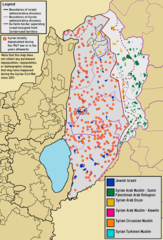
English: Demographic map of The Golan Heights overlaid with location of Syrian localities whose residents have been displaced since 1967, including the Israeli-occupied "Golan Subdistrict" and the Syrian-ruled "Quneitra Governorate".
العربية: خريطة توزع الديموغرافي لهضبة الجولان بالإضافة إلى مواقع القرى والبلدات السورية المهجورة، التي تشمل «قضاء مرتفعات الجولان» التي تحتلها إسرائيل و «محافظة القنيطرة» التي تحت حكم سوريا.
עברית: מפה מפורטת של קבוצות אתניות ברמת הגולן הכוללת את "מחוז קוניטרה" תחת השלטון הסורי ו"נפת רמת הגולן" תחת השלטון/הכיבוש הישראלי ועליה מיקומם של יישובי סוריה שתושביו גורשו |
| Date | |
| Source |
Own work using the following information
|
| Author | BasilLeaf, using original work created by Bolter21 |
Licensing
I, the copyright holder of this work, hereby publish it under the following license:
This file is licensed under the Creative Commons Attribution-Share Alike 4.0 International license.
Attribution: Bolter21
- You are free:
- to share – to copy, distribute and transmit the work
- to remix – to adapt the work
- Under the following conditions:
- attribution – You must give appropriate credit, provide a link to the license, and indicate if changes were made. You may do so in any reasonable manner, but not in any way that suggests the licensor endorses you or your use.
- share alike – If you remix, transform, or build upon the material, you must distribute your contributions under the same or compatible license as the original.
File history
Click on a date/time to view the file as it appeared at that time.
| Date/Time | Thumbnail | Dimensions | User | Comment | |
|---|---|---|---|---|---|
| current | 17:31, 6 June 2022 | | 1,255 × 1,850 (169 KB) | BasilLeaf | Uploaded own work with UploadWizard |
File usage
The following pages on the English Wikipedia use this file (pages on other projects are not listed):
Global file usage
The following other wikis use this file:
- Usage on ar.wikipedia.org
- Usage on fa.wikipedia.org
- Usage on he.wikipedia.org