
File:Karte Nordostgrönland Koch 1911.png

Size of this preview: 465 × 600 pixels. Other resolutions: 186 × 240 pixels | 372 × 480 pixels | 596 × 768 pixels | 1,196 × 1,542 pixels.
Original file (1,196 × 1,542 pixels, file size: 1.46 MB, MIME type: image/png)
| This is a file from the Wikimedia Commons. Information from its description page there is shown below. Commons is a freely licensed media file repository. You can help. |
Summary
| Description |
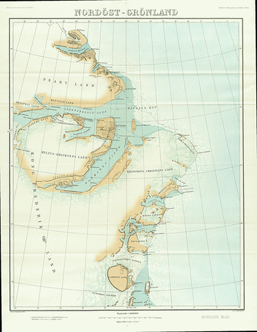
English: Map of North East Greenland by Johan Peter Koch as surveyed during the Danmark Expedition 1906-1908
Deutsch: Johan Peter Kochs Karte Nordostgrönlands, angefertigt nach der Landvermessung durch die Danmark-Expedition 1906-1908 |
| Date | |
| Source | J. P. Koch: Danmark-Ekspeditionens Kort, Geografisk Tidsskrift, 21 ,1911–1912, p. 167–177 ([1], p. 4 of 18) |
| Author | Johan Peter Koch (1870-1928) |
Licensing
|
This work is in the public domain in its country of origin and other countries and areas where the copyright term is the author's life plus 70 years or fewer. | |
| This file has been identified as being free of known restrictions under copyright law, including all related and neighboring rights. | |
File history
Click on a date/time to view the file as it appeared at that time.
| Date/Time | Thumbnail | Dimensions | User | Comment | |
|---|---|---|---|---|---|
| current | 11:21, 20 January 2019 | | 1,196 × 1,542 (1.46 MB) | Ratzer | bessere Auflösung? (Test) |
| 20:27, 3 June 2015 |  | 990 × 1,290 (677 KB) | Cmdrjameson | Compressed with pngout. Reduced by 823kB (54% decrease). | |
| 09:24, 13 June 2014 |  | 990 × 1,290 (1.47 MB) | Dreizung | {{Information |Description ={{en|1=Map of North East Greenland by Johan Peter Koch as surveyed during the Danmark Expedition 1906-1908}} {{de|1=Johan Peter Kochs Karte Nordostgrönlands, angefertigt nach der Landvermessung durch die Danmark-Expediti... |
File usage
The following pages on the English Wikipedia use this file (pages on other projects are not listed):
- Academy Glacier (Greenland)
- Amdrup Land
- Antarctic Bay (Greenland)
- Cape Bridgman
- Cape Clarence Wyckoff
- Daly Range
- Danmark Fjord
- Flade Isblink
- Frederick E. Hyde Fjord
- Hagen Fjord
- Herluf Trolle Land
- Holm Land
- Ingolf Fjord
- Lambert Land
- Lynn Island
- Mallemuk Mountain
- Mylius-Erichsen Land
- Princess Thyra Island
- Roosevelt Range
- Wyckoff Land
- Zachariae Isstrom
Global file usage
The following other wikis use this file:
- Usage on da.wikipedia.org
- Usage on de.wikipedia.org
- Usage on es.wikipedia.org
- Usage on fa.wikipedia.org
- Usage on fi.wikipedia.org
- Usage on fr.wikipedia.org
- Usage on it.wikipedia.org
- Usage on nl.wikipedia.org
- Usage on sv.wikipedia.org
- Usage on www.wikidata.org