
File:KettleCreekArrivalRoutes.jpg
Size of this preview: 489 × 599 pixels. Other resolutions: 196 × 240 pixels | 506 × 620 pixels.
Original file (506 × 620 pixels, file size: 86 KB, MIME type: image/jpeg)
| This is a file from the Wikimedia Commons. Information from its description page there is shown below. Commons is a freely licensed media file repository. You can help. |
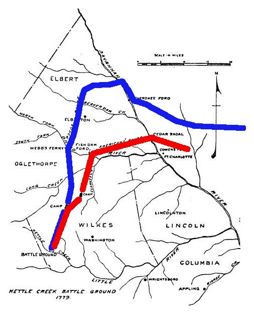
| Description | A 1926 map reconstructing the routes of American (Patriot) and British (Loyalist) forces prior to the 1779 w:Battle of Kettle Creek. The Loyalist route has been highlighted in blue, the Patriot route in red. |
| Date | |
| Source | Georgia Historical Quarterly |
| Author | Otis Ashmore and Charles Olmstead; annotations by User:Magicpiano |
| Permission (Reusing this file) |
Public domain, copyright not renewed; annotations are also PD |
This work is in the public domain because it was published in the United States between 1929 and 1963, and although there may or may not have been a copyright notice, the copyright was not renewed. For further explanation, see Commons:Hirtle chart and the copyright renewal logs. Note that it may still be copyrighted in jurisdictions that do not apply the rule of the shorter term for US works (depending on the date of the author's death), such as Canada (70 years p.m.a.), Mainland China (50 years p.m.a., not Hong Kong or Macao), Germany (70 years p.m.a.), Mexico (100 years p.m.a.), Switzerland (70 years p.m.a.), and other countries with individual treaties.
|
 |
File history
Click on a date/time to view the file as it appeared at that time.
| Date/Time | Thumbnail | Dimensions | User | Comment | |
|---|---|---|---|---|---|
| current | 15:31, 3 January 2012 | | 506 × 620 (86 KB) | Magicpiano | {{Information |Description=A 1926 map reconstructing the routes of American (Patriot) and British (Loyalist) forces prior to the 1779 w:Battle of Kettle Creek. The Loyalist route has been highlighted in blue, the Patriot route in red. |Source=Georgia |
File usage
The following pages on the English Wikipedia use this file (pages on other projects are not listed):
Global file usage
The following other wikis use this file:
- Usage on ja-two.iwiki.icu