
File:Keystone-map.png
Size of this preview: 800 × 415 pixels. Other resolutions: 320 × 166 pixels | 640 × 332 pixels | 1,346 × 699 pixels.
Original file (1,346 × 699 pixels, file size: 887 KB, MIME type: image/png)
| This is a file from the Wikimedia Commons. Information from its description page there is shown below. Commons is a freely licensed media file repository. You can help. |
Summary
| Description |
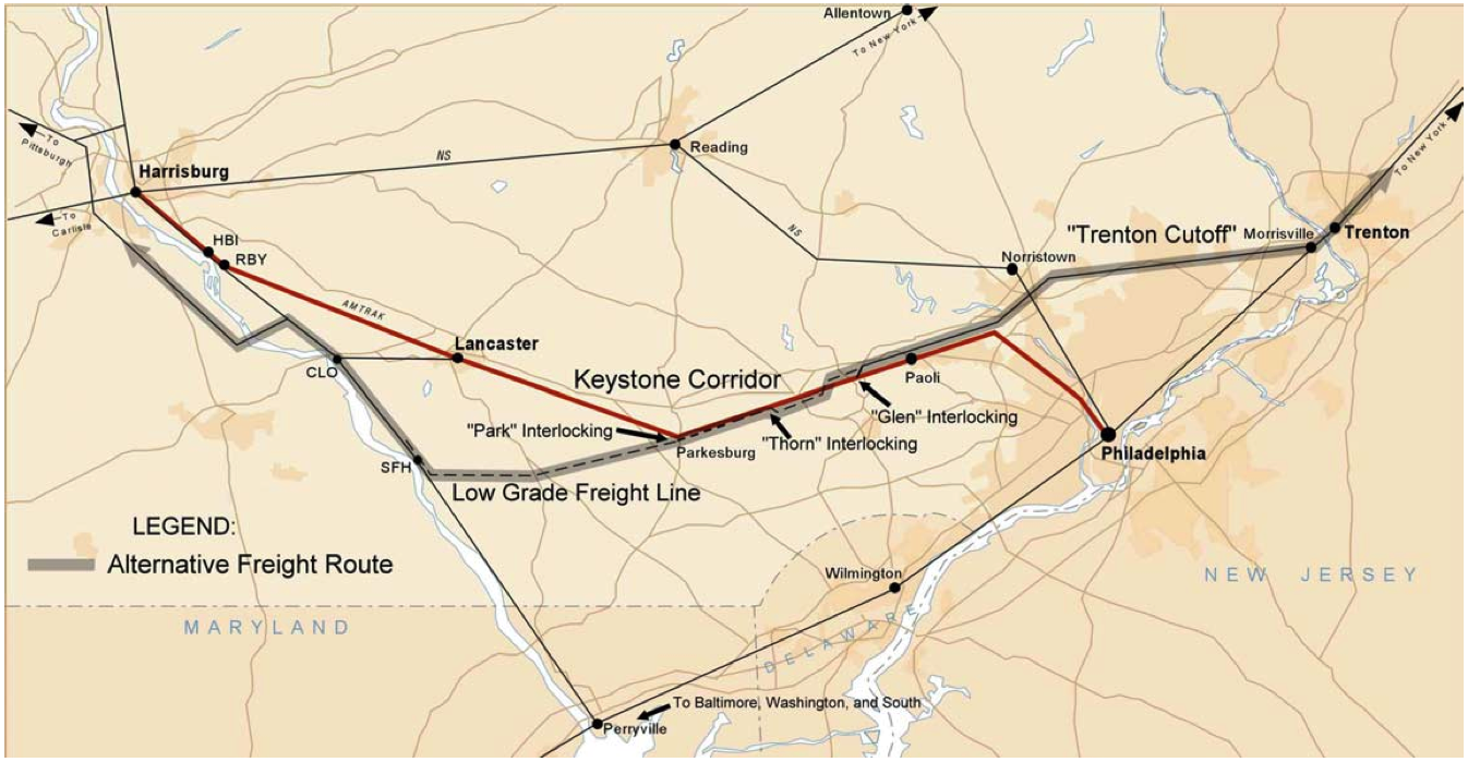
English: Map of Amtrak's Keystone Corridor, showing the partially-abandoned PRR low-grade freight line |
| Date | |
| Source |
Technical Monograph: Transportation Planning for the Philadelphia–Harrisburg “Keystone” Railroad Corridor Volume I: Executive Summary and Main Report 6. Performing Organization Code |
| Author | US DOT / Federal Railroad Administration |
Licensing
This work is in the public domain in the United States because it is a work prepared by an officer or employee of the United States Government as part of that person’s official duties under the terms of Title 17, Chapter 1, Section 105 of the US Code.
Note: This only applies to original works of the Federal Government and not to the work of any individual U.S. state, territory, commonwealth, county, municipality, or any other subdivision. This template also does not apply to postage stamp designs published by the United States Postal Service since 1978. (See § 313.6(C)(1) of Compendium of U.S. Copyright Office Practices). It also does not apply to certain US coins; see The US Mint Terms of Use.
|
 | |
| This file has been identified as being free of known restrictions under copyright law, including all related and neighboring rights. | ||
File history
Click on a date/time to view the file as it appeared at that time.
| Date/Time | Thumbnail | Dimensions | User | Comment | |
|---|---|---|---|---|---|
| current | 02:28, 26 November 2005 | | 1,346 × 699 (887 KB) | Luciuskwok~commonswiki | Description: Map of Amtrak's Keystone Corridor Source: Technical Monograph: Transportation Planning for the Philadelphia–Harrisburg “Keystone” Railroad Corridor⎯Volume I: Executive Summary and Main Report6. Performing Organization Code Date: Ma |
File usage
The following pages on the English Wikipedia use this file (pages on other projects are not listed):
Global file usage
The following other wikis use this file:
- Usage on www.wikidata.org