
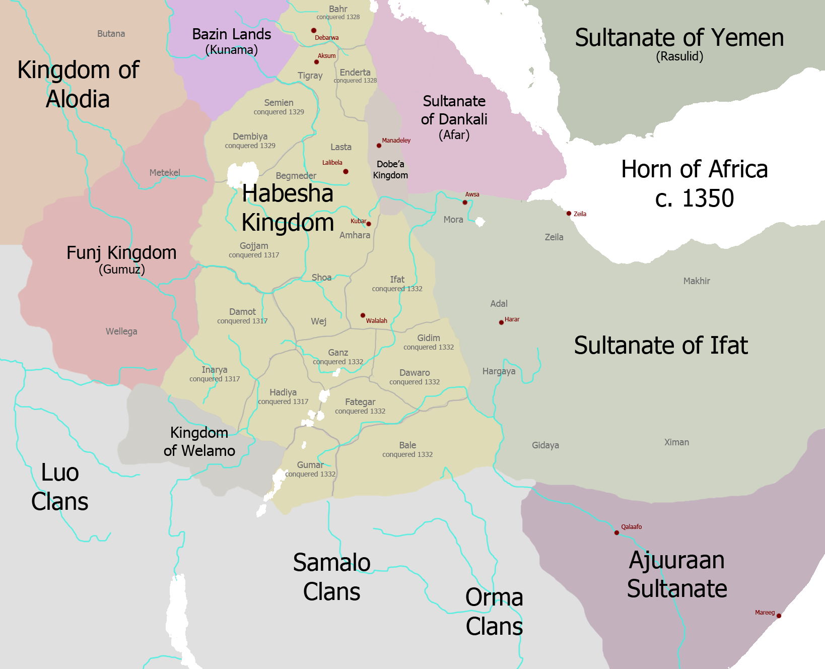
File:Map of Ethiopia circa 1350.png
Size of this preview: 740 × 600 pixels. Other resolutions: 296 × 240 pixels | 592 × 480 pixels | 947 × 768 pixels | 1,263 × 1,024 pixels | 1,638 × 1,328 pixels.
Original file (1,638 × 1,328 pixels, file size: 309 KB, MIME type: image/png)
| This is a file from the Wikimedia Commons. Information from its description page there is shown below. Commons is a freely licensed media file repository. You can help. |
Summary
| Description | |
| Date | |
| Source | Own work |
| Author | Ingoman |
Licensing
I, the copyright holder of this work, hereby publish it under the following license:
This file is licensed under the Creative Commons Attribution-Share Alike 3.0 Unported license.
- You are free:
- to share – to copy, distribute and transmit the work
- to remix – to adapt the work
- Under the following conditions:
- attribution – You must give appropriate credit, provide a link to the license, and indicate if changes were made. You may do so in any reasonable manner, but not in any way that suggests the licensor endorses you or your use.
- share alike – If you remix, transform, or build upon the material, you must distribute your contributions under the same or compatible license as the original.
File history
Click on a date/time to view the file as it appeared at that time.
| Date/Time | Thumbnail | Dimensions | User | Comment | |
|---|---|---|---|---|---|
| current | 21:17, 29 November 2013 | | 1,638 × 1,328 (309 KB) | Ingoman | more corrections |
| 21:15, 29 November 2013 |  | 1,638 × 1,328 (308 KB) | Ingoman | corrections | |
| 19:58, 28 November 2013 |  | 1,638 × 1,328 (306 KB) | Ingoman | Ajuran expansion too early, plus too early for Kaffa and Dawro as independent entities, Welamo is the rump Damot state. | |
| 22:32, 27 November 2013 |  | 1,638 × 1,328 (302 KB) | Ingoman | Darker map | |
| 22:25, 27 November 2013 |  | 1,638 × 1,328 (300 KB) | Ingoman | User created page with UploadWizard |
File usage
The following pages on the English Wikipedia use this file (pages on other projects are not listed):
Global file usage
The following other wikis use this file:
- Usage on sl.wikipedia.org