
File:Map of wales.jpg
Size of this preview: 142 × 597 pixels. Other resolutions: 57 × 240 pixels | 416 × 1,748 pixels.
Original file (416 × 1,748 pixels, file size: 392 KB, MIME type: image/jpeg)
| This is a file from the Wikimedia Commons. Information from its description page there is shown below. Commons is a freely licensed media file repository. You can help. |
Summary
| Description |
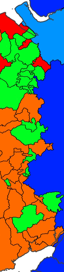
English: Wales prior to the effects of the laws in wales acts. the borders are assumed and should not be used as a source
Flintshire was administered by Cheshire |
| Date | |
| Source | Own work |
| Author | Editor account 2222 |
Licensing
I, the copyright holder of this work, hereby publish it under the following license:
This file is licensed under the Creative Commons Attribution-Share Alike 4.0 International license.
- You are free:
- to share – to copy, distribute and transmit the work
- to remix – to adapt the work
- Under the following conditions:
- attribution – You must give appropriate credit, provide a link to the license, and indicate if changes were made. You may do so in any reasonable manner, but not in any way that suggests the licensor endorses you or your use.
- share alike – If you remix, transform, or build upon the material, you must distribute your contributions under the same or compatible license as the original.
File history
Click on a date/time to view the file as it appeared at that time.
| Date/Time | Thumbnail | Dimensions | User | Comment | |
|---|---|---|---|---|---|
| current | 20:18, 11 September 2024 | 416 × 1,748 (392 KB) | Editor account 2222 | Exclave | |
| 18:05, 11 September 2024 | 416 × 1,748 (391 KB) | Editor account 2222 | Map | ||
| 19:17, 10 September 2024 | 416 × 1,748 (381 KB) | Editor account 2222 | New boundries | ||
| 18:55, 18 March 2024 | 208 × 874 (88 KB) | Editor account 2222 | Uploaded while editing "England–Wales border" on en-two.iwiki.icu |
File usage
The following pages on the English Wikipedia use this file (pages on other projects are not listed):