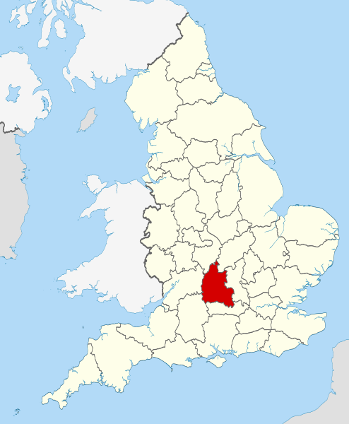
File:Oxfordshire UK locator map 2010.svg
Appearance

Size of this PNG preview of this SVG file: 494 × 600 pixels. Other resolutions: 198 × 240 pixels | 395 × 480 pixels | 633 × 768 pixels | 843 × 1,024 pixels | 1,687 × 2,048 pixels | 1,108 × 1,345 pixels.
Original file (SVG file, nominally 1,108 × 1,345 pixels, file size: 302 KB)
File history
Click on a date/time to view the file as it appeared at that time.
| Date/Time | Thumbnail | Dimensions | User | Comment | |
|---|---|---|---|---|---|
| current | 22:25, 23 November 2010 |  | 1,108 × 1,345 (302 KB) | Nilfanion | use ceremonial counties - corresponds with text of article better |
| 16:39, 23 November 2010 |  | 1,108 × 1,345 (332 KB) | Nilfanion | Fix coast - add Arran | |
| 00:47, 16 November 2010 |  | 1,108 × 1,345 (325 KB) | Nilfanion | thicker lines | |
| 00:44, 16 November 2010 |  | 1,108 × 1,345 (325 KB) | Nilfanion | {{Information |Description=Location of Oxfordshire within England, with the administrative counties shown. |Source=Ordnance Survey [https://www.ordnancesurvey.co.uk/opendatadownload/products.html OpenData]: *County |
File usage
More than 100 pages use this file. The following list shows the first 100 pages that use this file only. A full list is available.
- Abingdon Road
- Alfred Street
- Angel & Greyhound Meadow, Oxford
- Ardington
- Aston, Cote, Shifford and Chimney
- Aston Upthorpe
- Badbury Hill
- Barford St. John and St. Michael
- Battle Edge
- Bear Lane
- Beckley and Stowood
- Belbroughton Road
- Bix and Assendon
- Blenheim, Oxfordshire
- Blue Boar Street
- Bourton, Cherwell
- Brasenose Lane
- Brightwell Barrow
- Bruern
- Bullingdon Hundred
- Canterbury Road
- Caversham Lakes
- Charlbury Road
- Compton Beauchamp
- Cowley Road, Oxford
- Cumnor Hill
- Curbridge, Oxfordshire
- Dame's Delight
- Donnington, Oxfordshire
- Dragon Hill, Uffington
- Dunsden Green
- Examination Schools
- Farmoor
- Farmoor Reservoir
- Fencott and Murcott
- Founders Tower
- Fulscot
- Gallowstree Common
- Golden Cross, Oxford
- Gosford and Water Eaton
- Grimsbury Reservoir
- Hanney
- Headington Hill
- Headington Road
- Hinksey
- Hinksey Hill
- Keble Road
- King Edward Street
- Kingston Blount
- Kingston Road, Oxford
- List of parliamentary constituencies in Oxfordshire
- Logic Lane covered bridge
- Longwall Street
- Magdalen Street
- Magpie Lane, Oxford
- Market Street, Oxford
- Marston Ferry Road
- Mill Meadows, Henley-on-Thames
- Milton-under-Wychwood
- Municipal Borough of Abingdon
- Museum Road
- Noke, Oxfordshire
- Norham Gardens
- North Newington
- Oriel Square
- Oxford services
- Oxfordshire
- Peckwater Quadrangle
- Pembroke Square, Oxford
- Pembroke Street, Oxford
- Ploughley Rural District
- RAF Bampton Castle
- Radford, Oxfordshire
- Rainbow Bridge, Oxford
- Redgrave Pinsent Rowing Lake
- Risinghurst and Sandhills
- River Evenlode
- Roke
- Salford, Oxfordshire
- Science Area, Oxford
- South Hinksey
- South Parade
- South Parks Road
- South Weston
- St. Ebbes
- St Clement's, Oxford
- St Cross Road
- St John Street, Oxford
- St Michael's Street, Oxford
- Sunnymead
- Swinford, Oxfordshire
- Thames and Kennet Marina
- The Barley Mow, Clifton Hampden
- The Plain, Oxford
- The Trout Inn
- Trench Green
- Turf Tavern
- Waterperry
- Wellington Square, Oxford
- West Hagbourne
View more links to this file.
Global file usage
The following other wikis use this file:
- Usage on af.wikipedia.org
- Usage on an.wikipedia.org
- Usage on ar.wikipedia.org
- Usage on arz.wikipedia.org
- Usage on ast.wikipedia.org
- Usage on be-tarask.wikipedia.org
- Usage on bg.wikipedia.org
- Usage on bn.wikipedia.org
- Usage on br.wikipedia.org
- Usage on br.wiktionary.org
- Usage on ca.wikipedia.org
- Usage on ceb.wikipedia.org
- Usage on cs.wikipedia.org
- Usage on en.wikinews.org
- Usage on eo.wikipedia.org
- Usage on es.wikipedia.org
- Usage on et.wikipedia.org
- Usage on eu.wikipedia.org
- Usage on fa.wikipedia.org
- Usage on fi.wikipedia.org
- Usage on fr.wiktionary.org
- Usage on ga.wikipedia.org
- Usage on gl.wikipedia.org
- Usage on hak.wikipedia.org
- Usage on hr.wikipedia.org
- Usage on hu.wikipedia.org
- Usage on hy.wikipedia.org
- Usage on ia.wikipedia.org
- Usage on io.wikipedia.org
- Usage on ja-two.iwiki.icu
- Usage on ko.wikipedia.org
- Usage on la.wikipedia.org
- Usage on lld.wikipedia.org
- Usage on lt.wikipedia.org
- Usage on lv.wikipedia.org
- Usage on mr.wikipedia.org
- Usage on ms.wikipedia.org
View more global usage of this file.


