File:Stane Street map 2.png
Appearance
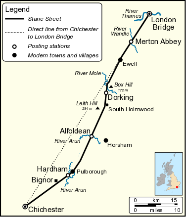
Stane_Street_map_2.png (376 × 439 pixels, file size: 48 KB, MIME type: image/png)
File history
Click on a date/time to view the file as it appeared at that time.
| Date/Time | Thumbnail | Dimensions | User | Comment | |
|---|---|---|---|---|---|
| current | 13:45, 8 October 2010 |  | 376 × 439 (48 KB) | Mertbiol | {{Information |Description={{en|1=Map of Stane Street, a road constructed by the Romans in south east England. This map was drawn after I. D. Margary, ''Roman Ways in the Weald'' 1965 Phoenix House.}} |Source={{own}} |Author=Mertbiol |Da |
File usage
The following page uses this file:
Global file usage
The following other wikis use this file:
- Usage on cs.wikipedia.org
- Usage on de.wikipedia.org
- Usage on fr.wikipedia.org
- Usage on hr.wikipedia.org
- Usage on it.wikipedia.org
- Usage on no.wikipedia.org

