
File:Thames Tunnel-route.png

Size of this preview: 325 × 599 pixels. Other resolutions: 130 × 240 pixels | 260 × 480 pixels | 416 × 768 pixels | 555 × 1,024 pixels | 2,168 × 3,998 pixels.
Original file (2,168 × 3,998 pixels, file size: 7.16 MB, MIME type: image/png)
| This is a file from the Wikimedia Commons. Information from its description page there is shown below. Commons is a freely licensed media file repository. You can help. |
Summary
| Description |
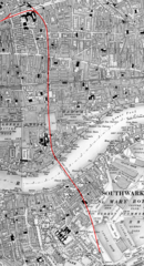
English: Map of the underground routing and approaches (highlighted in RED) to the Thames Tunnel, London UK, beginning at Whitechapel station and continuing south under Shadwell until reaching Wapping railway station, thence through the Thames Tunnel under the River Thames to Rotherhithe station and still underground passes beneath Southwark until it emerges from the ground near Deptford Road Station. |
| Date | 29 July 2019 (upload date) |
| Source | The uploader on Wikimedia Commons received this from the author/copyright holder via photosubmissions. |
| Author | Route highlighting in RED by Jonathan Bluestone, derived from an Ordnance Survey map published ca. 1889 |
| Permission (Reusing this file) |
Licensing
Derivative work:
| This file is made available under the Creative Commons CC0 1.0 Universal Public Domain Dedication. | |
| The person who associated a work with this deed has dedicated the work to the public domain by waiving all of their rights to the work worldwide under copyright law, including all related and neighboring rights, to the extent allowed by law. You can copy, modify, distribute and perform the work, even for commercial purposes, all without asking permission.
|
Map:
This work is an Ordnance Survey map over 50 years old, which is covered by Crown Copyright which in this case expires 50 years after publication. Ordnance Survey does however ask that they be credited and that the date of publication be given.
Any ancillary rights gained through the creation of the electronic version are granted as freely usable under any circumstances.
|
This work created by the United Kingdom Government is in the public domain.
This is because it is one of the following:
HMSO has declared that the expiry of Crown Copyrights applies worldwide (ref: HMSO Email Reply)
|
 |
File history
Click on a date/time to view the file as it appeared at that time.
| Date/Time | Thumbnail | Dimensions | User | Comment | |
|---|---|---|---|---|---|
| current | 12:36, 29 July 2019 | | 2,168 × 3,998 (7.16 MB) | JGHowes | {{Information |Description={{en|1=Map of '''{{w|Thames Tunnel}}''', London UK. The underground portion is highlighted in <font color=red>'''''RED'''''</font color> beginning at {{w|Whitechapel station}} and continuing south under Shadwell until it reaches the Thames at {{w|Wapping railway station}}, where it goes under the Thames to {{w|Rotherhithe station}} and still underground passes beneath Southwark until it emerges from the ground close to Deptford Road Station.}} |Source={{author sourc... |
File usage
The following pages on the English Wikipedia use this file (pages on other projects are not listed):
Global file usage
The following other wikis use this file:
- Usage on eo.wikipedia.org
- Usage on es.wikipedia.org
- Usage on it.wikipedia.org