
File:The Map of Early Penang Showing the Malay Town on the South of the Town Center by Popham 1799 overlaid with OSM.png

Size of this preview: 619 × 599 pixels. Other resolutions: 248 × 240 pixels | 496 × 480 pixels | 793 × 768 pixels | 1,057 × 1,024 pixels | 2,024 × 1,960 pixels.
Original file (2,024 × 1,960 pixels, file size: 593 KB, MIME type: image/png)
| This is a file from the Wikimedia Commons. Information from its description page there is shown below. Commons is a freely licensed media file repository. You can help. |
Summary
| Description |
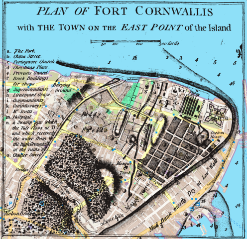
English: The Map of Early Penang Showing the Malay Town on the South of the Town Center by Popham 1799 overlaid with a modern map |
|
| Date | ||
| Source |
OpenStreetMap, and Popham, Home Riggs. Description of Prince of Wales Island in the Straits of Malacca with Its Advantages as a Marine Establishment. London.
|
|
| Author | OpenStreetMap contributors, Sir Home Riggs Popham |

Licensing
This file is licensed under the Creative Commons Attribution-Share Alike 2.0 Generic license.
- You are free:
- to share – to copy, distribute and transmit the work
- to remix – to adapt the work
- Under the following conditions:
- attribution – You must give appropriate credit, provide a link to the license, and indicate if changes were made. You may do so in any reasonable manner, but not in any way that suggests the licensor endorses you or your use.
- share alike – If you remix, transform, or build upon the material, you must distribute your contributions under the same or compatible license as the original.
File history
Click on a date/time to view the file as it appeared at that time.
| Date/Time | Thumbnail | Dimensions | User | Comment | |
|---|---|---|---|---|---|
| current | 13:43, 8 March 2024 | | 2,024 × 1,960 (593 KB) | Cmglee | Uploaded a work by OpenStreetMap contributors, Sir Home Riggs Popham from OpenStreetMap, and Popham, Home Riggs. Description of Prince of Wales Island in the Straits of Malacca with Its Advantages as a Marine Establishment. London. with UploadWizard |
File usage
The following pages on the English Wikipedia use this file (pages on other projects are not listed):