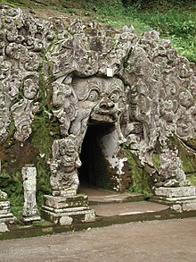
Goa Gajah


Goa Gajah, or Elephant Cave, is located on the island of Bali near Ubud, in Indonesia. Built in the 9th century, it served as a sanctuary.[1]
History
The origins of the cave are uncertain; one folklore relates that it was created by the fingernail of the legendary giant Kebo Iwa. However, examining its style, the sanctuary was probably dated from the 11th century Bali Kingdom. The complex contains both Hindu and Buddhist imagery, as the cave contains lingam and yoni, symbol of Shiva, and the image of Ganesha, while by the river there are carved images of stupas and chattra, imagery of Buddhism.
The cave was rediscovered by Dutch archaeologists in 1923, but the fountains and pool were not discovered until 1954.[2]
Site description
At the façade of the cave is a relief of various menacing creatures and demons carved into the rock at the cave entrance. The primary figure was once thought to be an elephant, hence the nickname Elephant Cave. The site is mentioned in the Javanese poem Desawarnana written in 1365. An extensive bathing place on the site was not excavated until the 1950s.[3] These appear to have been built to ward off evil spirits.
World Heritage Status
This site was added to the UNESCO World Heritage Tentative List on October 19, 1995, in the Cultural category.[4]
Notes
- ^ Davison, J. et al. (2003)
- ^ Planet, Lonely. "Goa Gajah in Bedulu, Indonesia". Lonely Planet. Retrieved 2017-12-27.
- ^ Pringle, R. (2004) p 61
- ^ Elephant Cave - UNESCO World Heritage Centre
External links
 Central Bali travel guide from Wikivoyage
References
- Elephant Cave - UNESCO World Heritage Centre Accessed 2009-03-06.
- Pringle, Robert (2004). Bali: Indonesia's Hindu Realm; A short history of. Short History of Asia Series. Allen & Unwin. ISBN 1-86508-863-3.
- Davison, J.; Nengah Enu; Bruce Granquist; Luca Invernizzi Tettoni (2003). Introduction to Balinese Architecture. Tuttle Publishing. ISBN 0-7946-0071-9.
