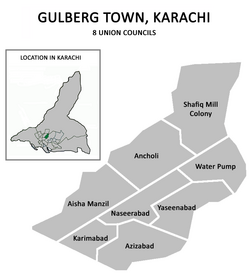
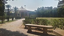
Gulberg Town, Karachi
Gulberg Town
گلبرگ ٹاؤن | |
|---|---|
 | |
 Gulberg Town was divided into 8 Union Councils | |
| Country | Pakistan |
| Province | Sindh |
| City District | Karachi |
| Established | 14 August 2001 |
| Union Councils | 8
|
| Government | |
| • Type | Government of Karachi |
| • Town Chaiman | Nusrat Ullah |
| Area | |
• Total | 14 km2 (5 sq mi) |
| Elevation | 36 m (118 ft) |
| Population | |
• Total | 613,724 |
| • Density | 43,837.43/km2 (113,538.4/sq mi) |
| Time zone | UTC+05:00 (PKT) |
| • Summer (DST) | DST is not observed |
| ZIP Code | |
| NWD (area) code | 021 |
| ISO 3166 code | PK-SD |

Gulberg Town (Sindhi and Urdu: گلبرگ) lies in the northern part of Karachi, Pakistan. Gulberg Town was formed in 2001 as part of the Local Government Ordinance 2001, and was subdivided into 11 union councils. The town system was disbanded in 2011,[1] and Gulberg Town was re-organized as part of Karachi Central District in 2015 and the Karachi Towns were restored in early 2022.[2]
Demographics
[edit]There are 613,724 people in Gulberg Subdivision of which 502,002 spoke Urdu, 26,576 Pashto, 21,243 Punjabi, 15,542 Saraiki, 13,310 Sindhi & 35,051 others
Location
[edit]Gulberg Town was bordered by the Lyari River and Gulshan Town to the east and the Gujjar Nala stream and North Nazimabad Town to the west. Also neighbouring Gulberg were New Karachi and Gadap to the north and Liaquatabad to the south.
History
[edit]The federal government introduced local government reforms in the year 2000, which eliminated the previous "third tier of government" (administrative divisions) and replaced it with the fourth tier (districts). The effect in Karachi was the dissolution of the former Karachi Division in 2001, and the merging of its five districts to form a new Karachi City-District with eighteen autonomous constituent towns including Gulberg Town. In 2011, the system was disbanded but remained in place for bureaucratic administration until 2015, when the Karachi Metropolitan Corporation system was reintroduced. In 2015, Gulberg Town was re-organized as part of Karachi Central district.[4] It is worth mentioning that Aisha Manzil was the name of a single story bungalow that that was built in late sixties just opposite the road where Arshi cinema was built later on.
Education and academia
[edit]Apart from the socio-economic diversification, this town had the distinction of being one of the most literate middle/upper middle class parts of the city along with North Nazimabad Town. There were numerous coaching centres in Gulberg Town.
"Markaz-e-Umeed" (The Hope Center) is one of the oldest schools for intellectually disabled children in Pakistan, established in 1971.
Hospitals
[edit]- Tabba Heart Institute
- Habib Medical Center
- Aga Khan Hospital for Women Karimabad (Ayesha Manzil)
- Usman Memorial Hospital
- Mamji Hospital
- Aziza Husseni Hospital
- Karachi Institute of Heart Diseases
- Federal Hospital
- Alnoor Hospital
- Muhammadi Hospital
- Rafah-e-aam Medical
- Nazeer hussain Hospital
- Mother care Hospital
Neighbourhoods
[edit]- Samanabad
- Aisha Manzil[4]
- Ancholi
- Alnoor Society
- Azizabad[4]
- Karimabad[4]
- Shafiq Mill Colony
- Naseerabad[4]
- Water Pump
- Yaseenabad[4]
- Musa Colony
- Dastagir Colony
- Hussainabad
References
[edit]- ^ Gayer, Laurent (2014). Karachi: Ordered Disorder and the Struggle for the City. Oxford University Press. ISBN 978-0-19-935444-3.
- ^ Tahir Siddiqui (8 January 2022). "Division of Karachi into 26 towns, 233 UCs notified (by the government)". Dawn (newspaper). Retrieved 19 January 2023.
- ^ "TABLE 11 – POPULATION BY MOTHER TONGUE, SEX AND RURAL/ URBAN" (PDF). Pakistan Bureau of Statistics. Retrieved 20 July 2024.
- ^ a b c d e f "Gulberg Town". City District Government of Karachi website. Archived from the original on 13 June 2006. Retrieved 19 January 2023.
External links
[edit]- Districts of Karachi Archived 30 May 2014 at the Wayback Machine
24°56′13″N 67°04′33″E / 24.9369°N 67.0759°E
