
Portal:Michigan highways
Michigan Highways
The State Trunkline Highway System of the US state of Michigan is a network of roads owned and maintained by the Michigan Department of Transportation (MDOT). The most prominent of these roads are part of one of three numbered highway systems in Michigan: Interstates Highways, US Highways, and the other State Trunklines. Other systems of roads are operated by the 83 counties in the state as well as each city.


Interstate Highways and US Highways are assigned at the national level. Interstate Highways are numbered in a grid—even-numbered highways are east–west highways (with the lowest numbers along Mexico and the Gulf of Mexico), and odd-numbered highways are north–south highways (with the lowest numbers along the Pacific Ocean). US Highways are also numbered in a grid—even numbered for east–west highways (with the lowest numbers along Canada) and odd numbered for north–south highways (with the lowest numbers along the Atlantic Ocean). For this reason, mainline (two-digit) Interstate Highways in Michigan all have numbers above 69 and mainline US Highways all have numbers below 45. Three-digit Interstate and U.S. Highways, also known as "child routes," are branches off their main one- or two-digit "parents". The Interstate and US Highways are maintained by MDOT. Interstate 75 (I-75) and US Highway 23 (US 23) are the longest examples in the state.


State Trunklines are the other state highways maintained by MDOT. These highways are completely owned and maintained by the state. Michigan highways are properly referred to using the M and never as "Route 28" or "Highway 115", but as M-28 or M-115. The marker used for state trunklines is a diamond with a block-letter "M" at the top. Roads that are maintained by the state but not assigned a state trunkline designation carry an unsigned highway designation.


County-Designated Highways are assigned numbers in a zone system by MDOT, but maintained by the counties. Each zone is indicated by a letter A–H which is followed by a number based on a grid inside that zone. Each county also maintains any other roadway that is not a state trunkline or a city street. The numbering and signing practices vary from county to county, as does the size of each county's system. Numerical designations typically do not carry over from one county to the next; a CDH that crosses county lines keeps its designation in each county however. County road designations are typically abbreviated "CR" or "Co Rd" followed by the number, and CDHs are abbreviated to just their letter and number assignment.
 Recognized content -
M-6, or the Paul B. Henry Freeway, is a 19.7-mile-long (31.7 km) east–west freeway and state trunkline highway in the United States that serves portions of southern Kent and eastern Ottawa counties south of Grand Rapids, Michigan. Although the freeway is named for Paul B. Henry, local residents and the press continue to use the original name, South Beltline as well on occasion. The freeway connects Interstate 196 (I-196) on the west with I-96 on the east. M-6 also provides a connection to U.S. Highway 131 (US 131) in the middle of its corridor while running through several townships on the south side of the Grand Rapids metropolitan area in Western Michigan. Each end is in a rural area while the central section has suburban development along the trunkline.
The freeway was originally conceived in the 1960s. It took 32 years to approve, plan, finance, and build the freeway from the time that the state first authorized funding in 1972 to the time of the ribbon-cutting ceremony in 2004 that opened the South Beltline to traffic. The project cost around $700 million or around $35 million per mile (approximately $22 million per kilometer). Initial construction started in November 1997, with the first phase opened in November 2001. The full freeway was opened in November 2004. The first phase of construction was completed in asphalt, while the second and third phases were built in concrete. The project was built with two firsts: the first single-point urban interchange (SPUI; /ˈspuːiː/) in Michigan, and a new technique to apply the pavement markings, embedding them into the concrete to reduce the chance of a snowplow scraping them off. In advance of the opening of the freeway to traffic, the Michigan Department of Transportation (MDOT) allowed the public to walk or bike the South Beltline in an open-house event called the "Southbelt Shuffle". (Full article...)
General images
-
 Map of the pre-statehood Indian trails
 -
 A-2 in Allegan County south of Holland
 -
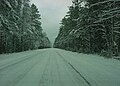 H-13 during winter
 -
 Grand River Avenue, once a part of M-16 and later US 16, was originally an Indian trail converted as a plank road before becoming a state highway.
 -
 M-39 bridge over the River Rouge in Dearborn
 -
 M-87 on November 1, 1956
 -
 Planning map for the Detroit area freeways from 1955
 -
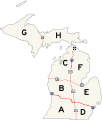 Map of the zone system
 -
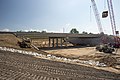 Construction along I-96 for the interchange with M-231 in July 2013 (from Michigan State Trunkline Highway System)
 -
 Junction between M-28 and M-178 south of Munising before 1941
 -
 H-58 west of Grand Marais
 -
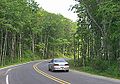
 M-121 in Jenison
 -
 Welcome sign along US 8
 -
 Milemarker used in 1922 for M-14
 -
 M-553 approaching Glass' Curve south of Marquette
 -
 Interstate HighwaysOther freewaysMiscellaneous expressways
 -
 Dead Man's Curve along the Marquette–Negaunee Road shown in 1917 with its hand-painted centerline, the first in the nation
 -
 Exit 254 on I-75 south of Grayling

.JPG)


.jpg)


Selected picture

Topics
State Trunkline System, overview of the system
- Interstates Highways in the state
- US Highways in the state
- State Trunklines
- County-Designated Highways in the state
- Pure Michigan Byways, a system of scenic, historical or recreational highways in the state
- Great Lakes Circle Tour
Subcategories
Related portals
WikiProjects
Things to do
Nominations and votes for selected articles and selected pictures are always needed. Anyone can nominate an article, and anyone can vote for an article. You can also recommend items for Did you know?. Improvements to the articles are always welcome as the project works on expanding and nominating the remaining ones for Good Article or Featured Article status.


