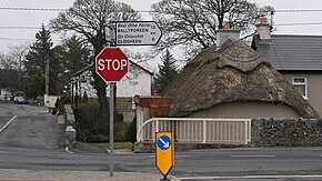
R668 road (Ireland)
Appearance
(Redirected from R668 road)
| R668 road | ||||
|---|---|---|---|---|
| Bóthar R668 | ||||
 R668 through Ballylooby | ||||
| Major junctions | ||||
| From | ||||
| ||||
| To | ||||
| Location | ||||
| Country | Ireland | |||
| Highway system | ||||
| ||||
The R668 road is a regional road in Ireland from Lismore, County Waterford to Cahir in County Tipperary, through Clogheen and Ballylooby. The Lismore–Clogheen section is a scenic route through the Vee Gap (Irish: Bóthar na gCorr[1]) in the Knockmealdown Mountains, between Sugarloaf Hill and Knockshanahullion.[2]
In the eighteenth century, the Cahir–Clogheen section was part of the main road from Cashel to Cork city.[3] It was superseded in the early 19th century by the construction of what is now the R639 road between Cahir and Mitchelstown.
The R665 crosses the R668 at Clogheen.[4] At Glentanagree Bridge, the R669 forks off to the south east past Mount Melleray to Cappoquin.[5]
References
[edit]- ^ "Bóthar na gCorr / The Vee". Placenames Database of Ireland. Retrieved 24 June 2012.
- ^ "604241,611894". Mapviewer. Ordnance Survey Ireland. Retrieved 24 June 2012.
- ^ Taylor, George; Andrew Skinner (1778). "Maps of the Roads of Ireland, surveyed 1777". London: G. Terry. Retrieved 24 June 2012.
- ^ "600325,614116". Mapviewer. Ordnance Survey Ireland. Retrieved 24 June 2012.
- ^ "603998,607814". Mapviewer. Ordnance Survey Ireland. Retrieved 24 June 2012.

