Talas Region
Talas Region
| |
|---|---|
 Landscape in Talas Region | |
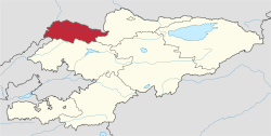
 Map of Kyrgyzstan, location of Talas Province highlighted | |
| Coordinates: 42°30′N 72°30′E / 42.500°N 72.500°E | |
| Country | |
| Capital | Talas |
| Government | |
| • Gubernator | Nurlan Dardanov[1] |
| Area | |
• Total | 13,406 km2 (5,176 sq mi) |
| Population (2023-01-01)[2] | |
• Total | 273,509 |
| • Density | 20/km2 (53/sq mi) |
| Time zone | UTC+6 (KGT) |
| ISO 3166 code | KG-T |
| Districts | 4 |
| Cities | 1 |
| Villages | 90 |
Talas Region (Kyrgyz: Талас облусу, romanized: Talas oblusu; Russian: Таласская область, romanized: Talasskaya oblast) is a region (oblast) of Kyrgyzstan. Its capital is Talas.[3] It is bordered on the west and north by Jambyl Region of Kazakhstan, on the east by Chüy Region, on the south by Jalal-Abad Region and on the southwest by a finger of Uzbekistan. Its total area is 13,406 km2 (5,176 sq mi).[4] The resident population of the region was 270,994 as of January 2021.[2]
During the 8th-century, the Battle of Talas between the Abbasid Caliphate and the Tang dynasty was fought here, which culminated in Abbasid victory that led to the Islamization of Central Asia and subsequent abandonment of Buddhism in the region.
Geography
[edit]The Talas Region is a U-shaped valley open to the west. The northern border is defined by the Kyrgyz Ala-Too, which also forms the Chuy Region's southern border. At the eastern end, the Talas Ala-Too Range splits off and marks the southern border. The river Talas flows through the center of the valley. The main highway (A361) enters from the east over the Ötmök Pass (Can become impassible during winter due to weather) and goes down the valley to Taraz in Kazakhstan. Near the valley's mouth at Kyzyl-Adyr, one road goes north toward Taraz and the other south over the Kara-Buura Pass to Jalal-Abad Province. Before independence most trade links were with Taraz.
Divisions
[edit]The Talas Region is divided administratively into one city of regional significance (Talas), and four districts:[3]
| District | Seat | Map |
|---|---|---|
| Bakay-Ata District | Bakay-Ata | 
|
| Kara-Buura District | Kyzyl-Adyr | 
|
| Manas District | Pokrovka | 
|
| Talas District | Manas | 
|
There are no cities of district significance or urban-type settlements in the region.[3]
Basic Socio-Economic Indicators
[edit]The economically active population of Talas Region in 2009 was 98,815, of which 93,499 employed and 5,316 (5.4%) unemployed.[4]
- Export: 14.6 million US dollars (2008)[5]
- Import: 193.3 million US dollars (2008)[5]
- Direct Foreign Investments: 30,4 million US dollars (in 2008)[6]
Demographics
[edit]The population of Talas Region, according to the Population and Housing Census of 2009, amounted to 219.6 thousand (enumerated de facto population) or 226.8 thousand (de jure population).[4] The region's estimated population for the beginning of 2021 was 270,994.[2]
| Year | Pop. | ±% |
|---|---|---|
| 1970 | 140,747 | — |
| 1979 | 163,492 | +16.2% |
| 1989 | 192,509 | +17.7% |
| 1999 | 199,872 | +3.8% |
| 2009 | 226,779 | +13.5% |
| 2021 | 270,994 | +19.5% |
| Note: resident population; Sources:[4][2] | ||
Ethnic composition
[edit]According to the 2009 Census, the ethnic composition of the Talas Region (de jure population) was:[4]
| Ethnic group | Population | Proportion of Talas Province population |
|---|---|---|
| Kyrgyz | 208,399 | 91.9% |
| Kurds | 5,547 | 2.5% |
| Russians | 4,356 | 1.9% |
| Kazakhs | 3,049 | 1.3% |
| Uzbeks | 1,779 | 0.8% |
| Turks | 1,547 | 0.7% |
| Ukrainians | 500 | 0.2% |
| Germans | 384 | 0.2% |
| Tatars | 299 | 0.1% |
| other groups | 919 | 0.4% |
References
[edit]- ^ "Nurlan Dardanov appointed as presidential plenipotentiary representative in Talas region" (in Russian). Kyrgyz National Information Agency Kabar. March 2023.
- ^ a b c d "Population of regions, districts, towns, urban-type settlements, rural communities and villages of Kyrgyz Republic" (XLS) (in Russian). National Statistics Committee of the Kyrgyz Republic. 2021. Archived from the original on 10 November 2021.
- ^ a b c "Classification system of territorial units of the Kyrgyz Republic" (in Kyrgyz). National Statistics Committee of the Kyrgyz Republic. May 2021. pp. 63–67.
- ^ a b c d e "2009 population and housing census of the Kyrgyz Republic: Talas Region" (PDF) (in Russian). National Statistics Committee of the Kyrgyz Republic. 2010. pp. 12, 15, 37, 134.
- ^ a b "National Committee on Statistics (in Kyrgyz/Russian)" (PDF). Archived from the original (PDF) on July 22, 2011.
- ^ "National Committee on Statistics (in Kyrgyz/Russian)" (PDF). Archived from the original (PDF) on July 22, 2011.
- Works cited
- Laurence Mitchell, Kyrgyzstan, Bradt Travel Guides, 2008


