Watson Mill Bridge State Park
Watson Mill Covered Bridge and Mill Historic District | |
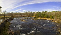
 Watson Mill State Park in late fall 2005 | |
| Nearest city | Comer, Georgia |
|---|---|
| Coordinates | 34°1′34″N 83°4′23″W / 34.02611°N 83.07306°W |
| Built | 1885 |
| Architect | W. W. King |
| Architectural style | Covered Town lattice truss |
| NRHP reference No. | 91001147[1] |
| Added to NRHP | September 5, 1991 |

Watson Mill Bridge State Park is a 1,018-acre (4.12 km2) Georgia state park located near Comer and Carlton on the South Fork of the Broad River. The park is named for the Watson Mill Bridge the longest original-site covered bridge in Georgia, which spans 229 feet (70 m) across the South Fork of the Broad River. The site is listed on the National Register of Historic Places as the Watson Mill Covered Bridge and Mill Historic District. The bridge, built in 1885,[2] is supported by a Town lattice truss system held together with wooden pegs also known as trunnels. Georgia once had over 200 covered bridges, but only 20 now remain. The park also offers a scenic nature trail and a new hiking/riding trail that winds through the thick forests and along the rivers edge.
Facilities
[edit]- 21 tent/trailer/RV sites
- 3 pioneer camping sites
- Group shelter
- 3 picnic shelters
- Boat rental
See also
[edit]- List of bridges on the National Register of Historic Places in Georgia
- List of bridges documented by the Historic American Engineering Record in Georgia (U.S. state)
- List of covered bridges in Georgia (U.S. state)
References
[edit]- ^ "National Register Information System". National Register of Historic Places. National Park Service. April 15, 2008.
- ^ "Watson Mill Bridge State Park". Wanderlust Atlanta. Retrieved June 29, 2019.
External links
[edit] Media related to Watson Mill Bridge at Wikimedia Commons
- Official website
- Watson Mill Covered Bridge State Park
- Historic American Engineering Record (HAER) No. GA-140, "Watson Mill Bridge, Spanning South Fork Broad River, Watson Mill Road, Watson Mill Bridge State Park, Comer, Madison County, GA", 14 photos, 9 data pages, 1 photo caption page
- State parks of Georgia (U.S. state)
- IUCN Category V
- Historic American Engineering Record in Georgia (U.S. state)
- Historic districts on the National Register of Historic Places in Georgia (U.S. state)
- Protected areas established in 1991
- Protected areas of Madison County, Georgia
- 1991 establishments in Georgia (U.S. state)
- National Register of Historic Places in Madison County, Georgia
- Covered bridges on the National Register of Historic Places in Georgia (U.S. state)
- Agricultural buildings and structures on the National Register of Historic Places in Georgia (U.S. state)
- Road bridges on the National Register of Historic Places in Georgia (U.S. state)
- Wooden bridges in Georgia (U.S. state)
- Lattice truss bridges in the United States
- Buildings and structures in Madison County, Georgia


