Transvaal (province)
| Province of Transvaal Provinsie van Transvaal | |
|---|---|
| Province of South Africa | |
| 1910–1994 | |
 | |
 The Transvaal as it was by 1994 | |
| Area | |
| • 1904[1] | 288,000 km2 (111,196 sq mi) |
| Population | |
| • 1904 | 1,268,716[1] |
| • 1991 | 9,491,265[2] |
| History | |
| • Origin | |
| • Created | 1910 |
| • Abolished | 27 April 1994 |
| • Succeeded by | Gauteng, Limpopo, Mpumalanga, and eastern part of North West |
| Status | Province of South Africa |
| Government | Transvaal Provincial Council |
| • HQ | |
| History | |
• Established | 1910 |
• Disestablished | 1994 |
The Province of Transvaal (Afrikaans: Provinsie van Transvaal), commonly referred to as the Transvaal (/ˈtrɑːnsvɑːl, ˈtræns-/; Afrikaans: [transˈfɑːl]), was a province of South Africa from 1910 until 1994, when a new constitution subdivided it following the end of apartheid. The name "Transvaal" refers to the province's geographical location to the north of the Vaal River. Its capital was Pretoria, which was also the country's executive capital.
History
[edit]In 1910, four British colonies united to form the Union of South Africa. The Transvaal Colony, which had been formed out of the bulk of the old South African Republic after the Second Boer War, became the Transvaal Province in the new union. Half a century later, in 1961, the union ceased to be part of the Commonwealth of Nations and became the Republic of South Africa. The PWV (Pretoria-Witwatersrand-Vereeniging) conurbation in the Transvaal, centred on Pretoria and Johannesburg, became South Africa's economic powerhouse, a position it still holds today as Gauteng Province.
In 1994, after the fall of apartheid, the former provinces were abolished, and the Transvaal ceased to exist. The south-central portion (including the PWV) became Gauteng, the northern portion became Limpopo and the southeastern portion became Mpumalanga. Most of the North West came from the southwestern portion of the old Transvaal, and a tiny segment of the Transvaal joined KwaZulu-Natal.
Even before 1994, the Transvaal Province was subdivided into regions for a number of purposes (such as municipal and district courts, and sporting divisions). These divisions included Northern Transvaal (present-day Limpopo and Pretoria), Eastern Transvaal (currently Mpumalanga), Western Transvaal (currently part of North West Province) and Southern Transvaal (now Gauteng Province, but which also includes Pretoria).
Geography
[edit]The Transvaal province lay between the Vaal River in the south, and the Limpopo River in the north, roughly between 22+1⁄2 and 27+1⁄2 S, and 25 and 32 E. To its south it bordered with the Orange Free State and Natal provinces, to its west were the Cape Province and the Bechuanaland Protectorate (later Botswana), to its north Rhodesia (later Zimbabwe), and to its east Portuguese East Africa (later Mozambique) and Swaziland. Except on the south-west, these borders were mostly well defined by natural features.
Several Bantustans were entirely inside the Transvaal: Venda, KwaNdebele, Gazankulu, KaNgwane and Lebowa. Parts of Bophuthatswana were also in the Transvaal, with other parts in Cape Province and Orange Free State.
Within the Transvaal lies the Waterberg Massif, a prominent ancient geological feature of the South African landscape.
Regions
[edit]This section needs expansion. You can help by adding to it. (March 2018) |
- PWV region (later Gauteng province) consisting of the Witwatersrand, which in turn consists of the West Rand and the East Rand, as well as Johannesburg; the Vaal Triangle and Pretoria.
- The North West
- Limpopo
- Mpumalanga
Districts in 1991
[edit]
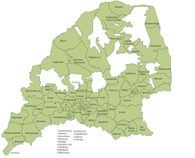
Districts of the province and population at the 1991 census.[2]
Administrators
[edit]Sports
[edit]The province was divided into a number of sporting teams. These teams were renamed after the Transvaal became defunct, however their traditional territories have remained unchanged in many cases, even though they overlap the boundaries of the Transvaal's successor provinces.
Examples of this include the Blue Bulls (formerly Northern Transvaal), which governs rugby in Pretoria (now part of Gauteng) and Limpopo Province, and the Golden Lions (formerly Transvaal) formed in 1889.
The Orlando Pirates Football Club was founded in 1937 and was originally based in Orlando, Soweto and Kaizer Chiefs were founded in January 1970. In the same year, Mamelodi Sundowns F.C. originated from Marabastad, a cosmopolitan area north west of the Pretoria CBD in the early 1960s.
Cricket teams from the former Transvaal include Transvaal (later Gauteng) which represented the southern parts of the province, and Northern Transvaal (later Northerns) that represents the northern parts of Gauteng, including Pretoria, as well as areas further north.[clarification needed]
References
[edit]- ^ a b Edgar Sanderson (1 November 2001). Great Britain in Africa: The History of Colonial Expansion. Simon Publications LLC. p. 149. ISBN 978-1-931541-31-2. Retrieved 10 September 2013.
- ^ a b "Census > 1991 > RSA > Variable Description > Person file > District code". Statistics South Africa – Nesstar WebView. Archived from the original on 19 June 2016. Retrieved 18 August 2013.
- ^ "Mine Kills 2 Whites in South Africa : Toll at 13 in Blasts Attributed to Black Guerrilla Offensive". Los Angeles Times. 5 January 1986. Retrieved 18 August 2013.

