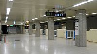
Ōdōri Station
Appearance
N07 T09 H08 Ōdōri Station 大通駅 | |||||||||||||||||||||
|---|---|---|---|---|---|---|---|---|---|---|---|---|---|---|---|---|---|---|---|---|---|
 The underground Northern ticket gates in April 2015 | |||||||||||||||||||||
| General information | |||||||||||||||||||||
| Location | Chūō-ku, Sapporo, Hokkaido Japan | ||||||||||||||||||||
| Operated by | Sapporo City Transportation Bureau | ||||||||||||||||||||
| Line(s) | |||||||||||||||||||||
| Platforms | 2 side platforms (Namboku Line) 1 island platform (Tōzai Line) 2 side platforms (Tōhō Line) | ||||||||||||||||||||
| Tracks | 6 | ||||||||||||||||||||
| Construction | |||||||||||||||||||||
| Accessible | Yes | ||||||||||||||||||||
| Other information | |||||||||||||||||||||
| Station code | N07 (Namboku Line) T09 (Tōzai Line) H08 (Tōhō Line)[1] | ||||||||||||||||||||
| History | |||||||||||||||||||||
| Opened | 16 December 1971 | ||||||||||||||||||||
| Passengers | |||||||||||||||||||||
| FY2014 (Daily) | 75,259[2] | ||||||||||||||||||||
| Services | |||||||||||||||||||||
| |||||||||||||||||||||
| |||||||||||||||||||||
Ōdōri Station (大通駅, Ōdōri Eki) is a subway station in Chūō-ku, Sapporo, Hokkaido, Japan, operated by Sapporo Municipal Subway. The station opened on 16 December 1971 as part of the first phase of the Namboku Line.[3]
Lines
[edit]Odori Station is served by all lines of the Sapporo Municipal Subway.
Platforms
[edit]Station layout
[edit]| G | Street Level | Exit/Entrance |
| B1F | Upper mezzanine | Namboku Line/Tōzai Line ticket barriers, ticket machines |
| B2F Namboku Line platforms |
Side platform, doors will open on the left | |
| Platform 2 | → Namboku Line for Asabu (Sapporo) → | |
| Platform 1 | ← Namboku Line for Makomanai (Susukino) | |
| Side platform, doors will open on the left | ||
| Transfer mezzanine | Transfer between Namboku/Tōzai Line platforms and Tōhō Line platforms Tōhō Line ticket barriers, ticket machines | |
| B3F Tōzai Line platforms |
Platform 3 | → Tōzai Line for Shin-Sapporo (Bus Center-Mae) → |
| Island platform, doors will open on the right | ||
| Platform 4 | ← Tōzai Line for Miyanosawa (Nishi-Jūitchōme) | |
| Lower mezzanine | Tōhō Line ticket barriers, ticket machines | |
| B4F Tōhō Line platforms |
Side platform, doors will open on the left | |
| Platform 6 | → Tōhō Line for Sakaemachi (Sapporo) → | |
| Platform 5 | ← Tōhō Line for Fukuzumi (Hōsui-Susukino) | |
| Side platform, doors will open on the left | ||
-
Train information board
-
Namboku Line platform
-
Tozai Line platform
-
Toho Line platform
Namboku Line
[edit]| 1 | ■ Namboku Line | for Makomanai |
| 2 | ■ Namboku Line | for Asabu |
Tōzai Line
[edit]| 3 | ■ Tōzai Line | for Shin-Sapporo |
| 4 | ■ Tōzai Line | for Miyanosawa |
Tōhō Line
[edit]| 5(Toho Line Track No.1) | ■ Tōhō Line | for Fukuzumi |
| 6(Toho Line Track No.2) | ■ Tōhō Line | for Sakaemachi |
Surrounding area
[edit]- Ōdōri Park
- 4th Ave (Sapporoeki-mae Avenue)
- Mitsukoshi
- Central business district
- Sapporo Citizens Hall
- Doshin Hall
- NHK Sapporo
- Sapporo TV Tower
- Sapporo Clock Tower
- Former Hokkaidō government office building
- Sapporo streetcar Nishi 4-Chome Station
- Hokkaido Police Headquarters
- Hokkaido University Botanical Gardens
- Tanukikoji shopping arcade
- Theater Kino
- Nijo fish market
- Hokkaido Chuo Bus Sapporo Terminal
- Odori bus Center Building
- Sapporo Grand Hotel
See also
[edit]References
[edit]- ^ "Route Map". City of Sapporo. Retrieved 2016-11-25.
- ^ "札幌の都市交通データ 4. 地下鉄" (PDF). www.city.sapporo.jp/sogokotsu/kotsutaikei/index.html (in Japanese). City of Sapporo. Archived from the original (PDF) on 2014-10-15. Retrieved 2016-11-25.
- ^ "地下鉄(高速電車)の概要" [Overview of the subway (high-speed train)]. city.sapporo.jp (in Japanese). Archived from the original on 19 January 2024. Retrieved 6 February 2024.
External links
[edit]Wikimedia Commons has media related to Odori Station.


