Agnew Lake (California)
Appearance
| Agnew Lake | |
|---|---|
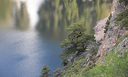
 Juniper tree along Agnew Lake | |
| Location | Mono County, California |
| Coordinates | 37°45′18″N 119°08′06″W / 37.755°N 119.135°W |
| Type | Lake |
| Etymology | Theodore C. Agnew, an early settler. |
| Basin countries | United States |
| Surface elevation | 8,501 feet (2,591 m) |
Agnew Lake is a lake in Mono County, California, in the United States.[1]
Agnew Lake was named for Theodore C. Agnew, an early settler.[2]
Climate
[edit]| Climate data for Soda Springs, California, 1991–2020 normals, extremes 1913–1959 | |||||||||||||
|---|---|---|---|---|---|---|---|---|---|---|---|---|---|
| Month | Jan | Feb | Mar | Apr | May | Jun | Jul | Aug | Sep | Oct | Nov | Dec | Year |
| Record high °F (°C) | 61 (16) |
70 (21) |
72 (22) |
76 (24) |
80 (27) |
89 (32) |
96 (36) |
90 (32) |
84 (29) |
75 (24) |
69 (21) |
65 (18) |
96 (36) |
| Mean maximum °F (°C) | 51 (11) |
54 (12) |
59 (15) |
64 (18) |
72 (22) |
80 (27) |
84 (29) |
82 (28) |
76 (24) |
68 (20) |
59 (15) |
53 (12) |
85 (29) |
| Mean daily maximum °F (°C) | 37.6 (3.1) |
38.8 (3.8) |
43.8 (6.6) |
50.7 (10.4) |
58.0 (14.4) |
64.8 (18.2) |
73.2 (22.9) |
71.3 (21.8) |
64.9 (18.3) |
55.4 (13.0) |
46.3 (7.9) |
38.4 (3.6) |
53.6 (12.0) |
| Daily mean °F (°C) | 24.9 (−3.9) |
26.5 (−3.1) |
30.0 (−1.1) |
36.7 (2.6) |
43.4 (6.3) |
50.1 (10.1) |
57.6 (14.2) |
55.6 (13.1) |
50.1 (10.1) |
41.9 (5.5) |
34.1 (1.2) |
26.9 (−2.8) |
39.8 (4.4) |
| Mean daily minimum °F (°C) | 14.8 (−9.6) |
14.7 (−9.6) |
18.3 (−7.6) |
21.2 (−6.0) |
28.8 (−1.8) |
35.3 (1.8) |
42.0 (5.6) |
39.9 (4.4) |
35.3 (1.8) |
28.4 (−2.0) |
22.0 (−5.6) |
15.4 (−9.2) |
26.3 (−3.1) |
| Mean minimum °F (°C) | −8.7 (−22.6) |
−9.3 (−22.9) |
−3.7 (−19.8) |
5.5 (−14.7) |
17.4 (−8.1) |
26.5 (−3.1) |
34.8 (1.6) |
33.9 (1.1) |
27.1 (−2.7) |
18.4 (−7.6) |
7.1 (−13.8) |
−2.3 (−19.1) |
−14 (−26) |
| Record low °F (°C) | −30 (−34) |
−26 (−32) |
−17 (−27) |
−10 (−23) |
5 (−15) |
14 (−10) |
20 (−7) |
17 (−8) |
12 (−11) |
3 (−16) |
−5 (−21) |
−22 (−30) |
−30 (−34) |
| Average precipitation inches (mm) | 3.63 (92) |
3.66 (93) |
2.92 (74) |
1.62 (41) |
0.86 (22) |
0.49 (12) |
0.55 (14) |
0.59 (15) |
0.70 (18) |
1.14 (29) |
2.11 (54) |
3.18 (81) |
21.45 (545) |
| Average snowfall inches (cm) | 33.2 (84) |
40.6 (103) |
26.3 (67) |
15.7 (40) |
4.3 (11) |
0.7 (1.8) |
0.0 (0.0) |
0.0 (0.0) |
1.1 (2.8) |
6.9 (18) |
16.8 (43) |
34.1 (87) |
179.7 (457.6) |
| Average extreme snow depth inches (cm) | 35 (89) |
58 (150) |
55 (140) |
51 (130) |
24 (61) |
4 (10) |
0 (0) |
0 (0) |
0 (0) |
1 (2.5) |
5 (13) |
17 (43) |
20 (51) |
| Average precipitation days (≥ 0.01 in) | 10 | 9 | 10 | 8 | 6 | 4 | 4 | 4 | 4 | 5 | 7 | 8 | 79 |
| Average snowy days (≥ 0.1 in) | 9 | 8 | 8 | 6 | 2 | 0 | 0 | 0 | 1 | 2 | 5 | 7 | 48 |
| Source: WRCC[3] | |||||||||||||
See also
[edit]References
[edit]- ^ U.S. Geological Survey Geographic Names Information System: Agnew Lake
- ^ Browning, Peter (2005). Yosemite Place Names: The Historic Background of Geographic Names in Yosemite National Park. Great West Books. p. 1. ISBN 978-0-944220-19-1.
- ^ "Gem Lake, CA Climate Data". Western Regional Climate Center. Retrieved November 8, 2023.


