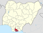
Ahoada East
Appearance
Ahoada East | |
|---|---|
| Coordinates: 5°4′6″N 6°38′48″E / 5.06833°N 6.64667°E | |
| Country | Nigeria |
| State | Rivers State |
| Headquarters | Ahoada |
| Date created | 1996 |
| Government | |
| • Local Government Chairman | Benjamin Eke (PDP) |
| • Deputy Local Government Chairman | Iyemewe Rose Ogbogo-Ololube (PDP) |
| • Local Government Council | Ward 1: Abraham Beatrice (PDP) Ward 2: Bright Uwandu (PDP) Ward 3: Uzoma Miller (PDP) Ward 4: Chisa Aguiyi (PDP) Ward 5: Alabi Umegbewe (PDP) Ward 6: Ogbenma Idalunimulu C (PDP) Ward 7: Nnamdi Aguyi Abule (PDP) Ward 8: Jeff Leventis (PDP) Ward 9: Alali Justice Livingstone (PDP) Ward 10: Kingsley Igwe (PDP) Ward 11: Thankgod Unwe Bernard (PDP) Ward 12: Nicholas Reuben Bob (PDP) Ward 13: Chituru Edi (PDP) |
| Area | |
| • Land | 132 sq mi (341 km2) |
| Time zone | UTC+1 (WAT) |
 | |
Ahoada East (also spelt Ehuda East) is a Local Government Area of Rivers State, Nigeria, located northwest of Port Harcourt. Its seat is in the city of Ahoada.[1] Towns in Ahoada East include Odiabidi, Edeoha, Ogbo, Abarikpo, Ihugbogo, etc
Climate/Geography
[edit]The average temperature and humidity of Ahoada East are expected to be 27 degrees Celsius and 88 percent, respectively. The region has two distinct seasons: the dry and the rainy. The rainy season is distinguished by frequent and intense downpours.[2][3]
References
[edit]- ^ "Ahoada East LGA". www.finelib.com. Retrieved 2023-05-06.
- ^ "Ahoada East Local Government Area". www.manpower.com.ng. Retrieved 2024-08-09.
- ^ "Weather Forecast and Conditions for Ahoada East, Rivers, Nigeria - The Weather Channel | Weather.com". The Weather Channel. Retrieved 2024-08-09.


