Al Ebb
Appearance
Al Ebb
العب | |
|---|---|
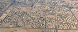
 Aerial view of Al Ebb | |
| Coordinates: 25°23′43″N 51°26′49″E / 25.395165°N 51.447079°E | |
| Country | |
| Municipality | Al Daayen |
| Zone | Zone 70 |
| District no. | 116 |
| Area | |
• Total | 7.0 km2 (2.7 sq mi) |
| Elevation | 14 m (46 ft) |
Al Ebb (Arabic: العب) is a settlement in the municipality of Al Daayen in Qatar.[3] It is located in the southern portion of the municipality, and is being developed as a residential hub.[4]
Etymology
[edit]Al Ebb derived its name from the Arabic term "abba" which roughly translates to "maximum capacity". It received its name due to its defining feature being a large depression, hosting various types of plants, which would be filled with water during the rainy months.[5]
References
[edit]- ^ "District Area Map". Ministry of Development Planning and Statistics. Retrieved 1 March 2019.
- ^ "Al Ebb, Zone 70, Qatar on the Elevation Map". elevationmap.net. Retrieved 5 January 2019.
- ^ "2015 Population census" (PDF). Ministry of Development Planning and Statistics. April 2015. Archived from the original (PDF) on 17 July 2016. Retrieved 21 May 2018.
- ^ "Al Daayen Municipality: Vision and Development Strategy" (PDF). Ministry of Municipality and Environment. December 2017. Retrieved 22 May 2018.
- ^ "District map". The Centre for Geographic Information Systems of Qatar. Archived from the original on 24 November 2020. Retrieved 21 May 2018.

