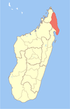
Ambalabe, Antalaha
This article relies largely or entirely on a single source. (March 2022) |
Ambalabe | |
|---|---|
| Coordinates: 15°10′S 50°25′E / 15.167°S 50.417°E | |
| Country | |
| Region | Sava |
| District | Antalaha |
| Population (2001)[1] | |
• Total | 16,250 |
| Time zone | UTC3 (EAT) |
Ambalabe is a town and commune (Malagasy: kaominina) in northern Madagascar. It belongs to the district of Antalaha, which is a part of Sava Region. According to 2001 commune census the population of Ambalabe was 16,250.[1]
Ambalabe has a riverine harbour. The majority 80% of the population are farmers, while an additional 13% receives their livelihood from raising livestock. The most important crop is vanilla, while other important products are sugarcane and rice. Services provide employment for 2% of the population. Additionally fishing employs 5% of the population.[1]
Ambalabe is known for its lush vegetation and tropical climate, typical of the region. The town is surrounded by dense forests, rivers, and waterfalls.[citation needed]
In addition to its agricultural significance, Antalaha offers opportunities for outdoor activities and exploration.[citation needed] The nearby rainforests and national parks provide habitat for a range of flora and fauna, including various species of lemurs, chameleons, and bird species.[citation needed] Visitors to the region engage in hiking, birdwatching and nature tours.[citation needed]
References and notes
[edit]- ^ a b c "ILO census data". Cornell University. 2002. Retrieved 2008-02-15.
15°10′S 50°25′E / 15.167°S 50.417°E


