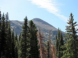
Appistoki Peak
Appearance
| Appistoki Peak | |
|---|---|
 Appistoki Peak from Two Medicine | |
| Highest point | |
| Elevation | 8,169 ft (2,490 m)[1] |
| Prominence | 497 ft (151 m)[1] |
| Coordinates | 48°28′4″N 113°21′15″W / 48.46778°N 113.35417°W[2] |
| Geography | |
| Location | Glacier County, Montana, U.S. |
| Parent range | Lewis Range |
| Topo map | USGS Squaw Mountain MT |
| Climbing | |
| Easiest route | Hike |
Appistoki Peak (8,169 feet (2,490 m)) is located in the Lewis Range, Glacier National Park in the U.S. state of Montana.[3] Appistoki Peak, "was named by R. T. Evans, a topographer who worked on the early map of the park. It is reported that he inquired from his Indian guide what word the Blackfeet used for "looking over something," and the guide, misunderstanding the meaning of his question, gave him the name "Appistoki," for the Indian god who looks over everything and everyone."[4] Appistoki Peak rises on the southeast shore of Two Medicine Lake and is a short distance north of Mount Henry.
See also
[edit]References
[edit]- ^ a b "Appistoki Peak, Montana". Peakbagger.com. Retrieved August 2, 2017.
- ^ "Appistoki Peak". Geographic Names Information System. United States Geological Survey, United States Department of the Interior. Retrieved August 2, 2017.
- ^ Dancing Lady Mountain, MT (Map). TopoQwest (United States Geological Survey Maps). Retrieved August 2, 2017.
- ^ "Historic Place Names". National Park Service. Retrieved August 2, 2017.


