Bokovskaya
Bokovskaya
Боковская | |
|---|---|
| Coordinates: 49°13′20″N 41°50′01″E / 49.22222°N 41.83361°E | |
| Country | Russia |
| Federal subject | Rostov Oblast[1] |
| Administrative district | Bokovsky District[1] |
| Founded | 1866 |
| Elevation | 94 m (308 ft) |
| Population | |
• Total | 4,832 |
| Time zone | UTC+3 (MSK |
| Postal code(s)[3] | 346250 |
| OKTMO ID | 60607411101 |
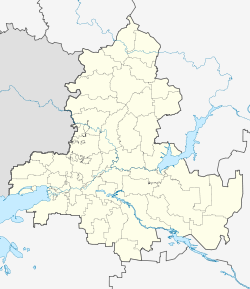
Bokovskaya (Russian: Боковская) is a rural locality (a stanitsa) in Bokovsky District of Rostov Oblast, Russia, located on the Chir River 354 kilometers (220 mi) south of Rostov-on-Don. Population: 4,832 (2010 Census);[1] 5,040 (2002 Census).[4] It is also the administrative center of Bokovsky District.
History
[edit]Before a stanitsa was established, there had already been a post station called Bokovskaya, which was first mentioned in official lists in 1873.[citation needed] At the end of the 19th century, the land near the Chir River was being quickly settled by Cossacks and peasants from other regions, although it was situated very far from any major cities.
According to the 1915 census, 395 people lived in the khutor of Bokov. There were two parish schools, a church and two mills. In 1918 the khutor changed its status to stanitsa.[5]
Landmarks
[edit]- St. John the Baptist Church
- Local History Museum of Bokovsky District
- "Heroes never perish" Memorial Complex
Also there are several archaeological sites around. The territory was first settled in the Neolithic Era, and many mounds have been preserved there. All of them are placed under state protection, as they are officially recognized as objects of cultural heritage of Russia[6]
References
[edit]- ^ a b c d e f Russian Federal State Statistics Service (2011). Всероссийская перепись населения 2010 года. Том 1 [2010 All-Russian Population Census, vol. 1]. Всероссийская перепись населения 2010 года [2010 All-Russia Population Census] (in Russian). Federal State Statistics Service.
- ^ "Об исчислении времени". Официальный интернет-портал правовой информации (in Russian). 3 June 2011. Retrieved 19 January 2019.
- ^ Почта России. Информационно-вычислительный центр ОАСУ РПО. (Russian Post). Поиск объектов почтовой связи (Postal Objects Search) (in Russian)
- ^ Federal State Statistics Service (21 May 2004). Численность населения России, субъектов Российской Федерации в составе федеральных округов, районов, городских поселений, сельских населённых пунктов – районных центров и сельских населённых пунктов с населением 3 тысячи и более человек [Population of Russia, Its Federal Districts, Federal Subjects, Districts, Urban Localities, Rural Localities—Administrative Centers, and Rural Localities with Population of Over 3,000] (XLS). Всероссийская перепись населения 2002 года [All-Russia Population Census of 2002] (in Russian).
- ^ История Боковского района
- ^ "Эпоха неолита в Ростовской области | Кладоискатель". donovedenie.ru. Retrieved 2017-10-04.


