Char Bangla Temples
| Char Bangla Temples | |
|---|---|
 ASI signage at the Char Bangla Temple complex in Baronagar | |
| Religion | |
| Affiliation | Hinduism |
| Location | |
| Location | Baranagar, Murshidabad |
| State | West Bengal |
| Country | India |
| Geographic coordinates | 24°15′08″N 88°14′37″E / 24.2521°N 88.2436°E |
| Architecture | |
| Type | Ek-bangla |
| Completed | 18th century |
Char Bangla Temples, are located at Baranagar in the Murshidabad-Jiaganj CD block in the Lalbag subdivision of Murshidabad district in the Indian state of West Bengal.
Geography
[edit]
5miles
Nala
River
River
border checkpost
M: municipal town, CT: census town, R: rural/ urban centre, H: historical place
Owing to space constraints in the small map, the actual locations in a larger map may vary slightly
Location
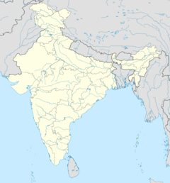
[edit]The Char Bangla Temples are located at 24°15′08″N 88°14′37″E / 24.2521°N 88.2436°E.
The temples
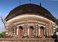
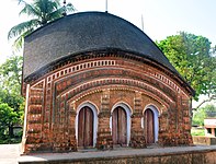
[edit]David J. McCutchion mentions the Char Bangla Temples at Baranagar as ek-bangla temples with triple entrance, measuring 31’ x 15–16.5’. The northern temple is dated 1760. Two of the temples have rich terracotta façade, one has incised plaster and the fourth one is plain. He says that apart from the Baranagar group, the ek-bangla is hardly found in West Bengal except in a “cursory form”[1]
According to the List of Monuments of National Importance in West Bengal the Char Bangla group of four Siva Mandirs are ASI listed monuments.[2]
History
[edit]The temples were built by Rani Bhabani of Natore. The temples are famous for their exquisite decorations based on either mythology or daily life. The tendency of the Ganges to change course frequently is threatening the existence of these heritage structures. The river, which earlier used to flow some distance away is now within yards from the temples.[3][4]
Char Bangla picture gallery
[edit]The temples
[edit]-
Temple 1
-
Temple 2
-
Temple 3
-
Temple 4
Decoration
[edit]References
[edit]- ^ McCutchion, David J., Late Mediaeval Temples of Bengal, first published 1972, reprinted 2017, pages 26,28, 30. The Asiatic Society, Kolkata, ISBN 978-93-81574-65-2
- ^ "List of Ancient Monuments and Archaeological Sites and Remains of West Bengal - Archaeological Survey of India". Item no. 111. ASI. Archived from the original on 1 August 2021. Retrieved 16 July 2021.
- ^ "250-year-old temple in Bengal village faces wrath of a river, administration sleeps". Kolkata News. Hindustan Times, 15 July 2017. Archived from the original on 16 July 2021. Retrieved 16 July 2021.
- ^ "The Char Bangla Temples of Murshidabad, West Bengal". Ancient Inquiries, 5 January 2021. Archived from the original on 16 July 2021. Retrieved 16 July 2021.
External links
[edit]![]() Murshidabad travel guide from Wikivoyage
Murshidabad travel guide from Wikivoyage


