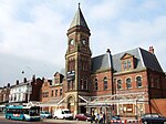
Church Road Garston railway station
Appearance
Church Road Garston Railway Station | |
|---|---|
| General information | |
| Location | Garston, Liverpool England |
| Coordinates | 53°21′12″N 2°53′59″W / 53.3532°N 2.8998°W |
| Grid reference | SJ403844 |
| Platforms | 2 |
| Other information | |
| Status | Disused |
| History | |
| Pre-grouping | LNWR |
| Post-grouping | London Midland and Scottish Railway |
| Key dates | |
| 1 March 1881 | Opened |
| 15 April 1917 | Closed |
| 5 May 1919 | Reopened |
| 3 July 1939 | Closed[1] |
Church Road Garston railway station was a station in Garston, Liverpool in England, it was situated on the west side of Church Road.
History
[edit]
The station opened on 1 March 1881 and closed 3 July 1939.[2]
| Preceding station | Disused railways | Following station | ||
|---|---|---|---|---|
| Garston Dock | LNWR St Helens Railway |
Speke | ||
| LNWR St Helens Railway |
Allerton |
References
[edit]- ^ Quick, M E (2002). Railway passenger stations in England, Scotland and Wales – a chronology. Richmond: Railway and Canal Historical Society. p. 191. OCLC 931112387.
- ^ Church Road Garston railway station at Disused Stations


