Dahongmen Subdistrict
Appearance
Dahongmen Subdistrict
大红门街道 | |
|---|---|
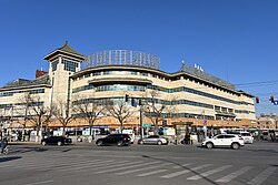
 Danbihua Market within the subdistrict, 2024 | |
| Coordinates: 39°50′15″N 116°24′03″E / 39.83750°N 116.40083°E | |
| Country | China |
| Municipality | Beijing |
| District | Fengtai |
| Village-level Divisions | 19 communities 2 village |
| Area | |
• Total | 9.6 km2 (3.7 sq mi) |
| Population (2020) | |
• Total | 177,946 |
| • Density | 19,000/km2 (48,000/sq mi) |
| Time zone | UTC+8 (China Standard) |
| Postal code | 100075 |
| Area code | 010 |
Dahongmen Subdistrict (Chinese: 大红门街道; pinyin: Dàhóngmén Jiēdào) is a subdistrict on the east side of Fengtai District, Beijing, China. It borders Xiluoyuan Subdistrict to the north, Xiaohongmen Township to the east, Nanyuan Township to the south, Majiabao Subdistrict to the west, and contains exclaves of Nanyuan Township within. The result of the 2020 Census determined the population to be at 177,946.[1]
This subdistrict's name (Chinese: 大红门; lit. 'Big Red Gate') referred to a former gate of Imperial Garden that once existed in this region during the Ming and Qing dynasty.[2]
History
[edit]| Years | Status |
|---|---|
| Before 1949 | Part of Daxing County |
| 1949 | Part of the 14th District |
| 1957 | Established as Dahongmen Township |
| 1958 | Became part of People's Commune of Nanyuan and transferred under Fengtai District |
| 1960 | Separated from Nanyuan and formed its own People's Commune |
| 1966 | Restructured into Dahongmen Subdistrict |
Administrative Division
[edit]In 2023, Dahongmen has direct jurisdiction over 21 subdivisions, of which 19 are communities and 2 are villages:[3]
| Administrative Division Code | Community Names | Name Transliteration | Type |
|---|---|---|---|
| 110106004001 | 西罗园南里 | Xiluoyuan Nanli | Community |
| 110106004002 | 西罗园南里果园 | Xiluoyuan Nanli Guoyuan | Community |
| 110106004003 | 西罗园南里华远 | Xiluoyuan Nanli Huayuan | Community |
| 110106004004 | 海户屯 | Haihutun | Community |
| 110106004005 | 木樨园南里 | Muxiyuan Nanli | Community |
| 110106004006 | 东罗园 | Dongluoyuan | Community |
| 110106004007 | 南顶村 | Nandingcun | Community |
| 110106004008 | 南顶路 | Nanding Lu | Community |
| 110106004009 | 康泽园 | Kangzeyuan | Community |
| 110106004010 | 时村 | Shicun | Community |
| 110106004015 | 大红门东街 | Dahongmen Dongjie | Community |
| 110106004017 | 苗圃东里 | Miaopu Dongli | Community |
| 110106004018 | 苗圃西里 | Miaopu Xili | Community |
| 110106004019 | 西马场南里 | Ximachang Nanli | Community |
| 110106004022 | 建欣苑 | Jianxinyuan | Community |
| 110106004028 | 远洋自然 | Yuanyang Ziran | Community |
| 110106004029 | 光彩路 | Guangcai Lu | Community |
| 110106004031 | 彩虹城第二 | Caihongcheng Di'er | Community |
| 110106004032 | 建欣苑东区 | Jianxinyuan Dongqu | Community |
| 110106004201 | 东罗园 | Dongluoyuan | Village |
| 110106004202 | 时 | Shi | Village |
See also
[edit]References
[edit]- ^ 国家统计局, ed. (2020). 中国统计年鉴 [China statistical yearbook]. Vol. 39 (1st ed.). Beijing: 中国统计出版社. ISBN 978-7-5037-9225-0. OCLC 1262741013.
- ^ a b 李立国; 李万钧; 吴世民, eds. (2013). 中华人民共和国政区大典, 北京市卷. Beijing: 中国社会出版社. ISBN 978-7-5087-4058-4. OCLC 910451741.
- ^ "2023年统计用区划代码和城乡划分代码". National Bureau of Statistics. Retrieved 2022-09-29.


