Ein HaHoresh
Ein HaHoresh
עֵין הַחוֹרֵשׁ عين هحوريش | |
|---|---|
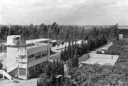
 Ein Hahoresh, c. 1940 | |
| Etymology: 'The Plowman's Spring' | |
| Coordinates: 32°23′18″N 34°56′26″E / 32.38833°N 34.94056°E | |
| Country | |
| District | Central |
| Council | Hefer Valley |
| Affiliation | Kibbutz Movement |
| Founded | 1931 |
| Founded by | Hashomer Hatzair |
| Population (2022)[1] | 874 |
Ein HaHoresh (Hebrew: עֵין הַחוֹרֵשׁ, lit. 'the plower's spring/the plowman's fountain') is a kibbutz in the Sharon region of the Central District of Israel. Located to the north of Netanya and to the south of Hadera, it falls under the jurisdiction of the Hefer Valley Regional Council. In 2022 it had a population of 874.[1]
History
[edit]It was founded in November 1931 by Hashomer Hatzair members from Eastern Europe. It was one of the first European settlements in the northern part of the Emek Hefer.[2] The kibbutz derived its name from Wadi al-Hawarith (Arabic: وادي الحوارث, lit. 'valley of ploughmen'), the Arabic name for the region.
The kibbutz was cordoned off and occupied by the British in December 1945 in connection with the struggle for free immigration. It was cordoned off and occupied by the British again in June 1946 along with its neighbor, Givat Haim. As part of the war effort, the kibbutz stepped up its food production.[2] By 1947 the kibbutz had a population of 450.[2] In 2005 it went through a privatization process.[3]
Economy
[edit]Pachmas Packaging, founded on the kibbutz in 1935, manufactures and markets rigid packaging for industrial markets.[4] Other economic branches are intensive citrus farming and milch cattle breeding.
Climate
[edit]| Climate data for Ein HaHoresh (1991–2020) | |||||||||||||
|---|---|---|---|---|---|---|---|---|---|---|---|---|---|
| Month | Jan | Feb | Mar | Apr | May | Jun | Jul | Aug | Sep | Oct | Nov | Dec | Year |
| Record high °C (°F) | 27.9 (82.2) |
32.7 (90.9) |
38.4 (101.1) |
40.9 (105.6) |
42.6 (108.7) |
42.4 (108.3) |
40.4 (104.7) |
38.7 (101.7) |
43.5 (110.3) |
41.2 (106.2) |
36.1 (97.0) |
31.0 (87.8) |
43.5 (110.3) |
| Mean daily maximum °C (°F) | 17.5 (63.5) |
18.5 (65.3) |
20.9 (69.6) |
24.2 (75.6) |
27.2 (81.0) |
29.1 (84.4) |
30.9 (87.6) |
31.5 (88.7) |
30.7 (87.3) |
28.8 (83.8) |
24.4 (75.9) |
19.6 (67.3) |
25.3 (77.5) |
| Daily mean °C (°F) | 12.2 (54.0) |
12.8 (55.0) |
14.7 (58.5) |
17.5 (63.5) |
20.7 (69.3) |
23.3 (73.9) |
25.6 (78.1) |
26.3 (79.3) |
24.8 (76.6) |
22.1 (71.8) |
18.0 (64.4) |
14.0 (57.2) |
19.3 (66.7) |
| Mean daily minimum °C (°F) | 6.9 (44.4) |
7.0 (44.6) |
8.5 (47.3) |
10.7 (51.3) |
14.2 (57.6) |
17.5 (63.5) |
20.4 (68.7) |
21.1 (70.0) |
18.8 (65.8) |
15.4 (59.7) |
11.5 (52.7) |
8.4 (47.1) |
13.4 (56.1) |
| Record low °C (°F) | −1.9 (28.6) |
−2.7 (27.1) |
−0.1 (31.8) |
0.9 (33.6) |
5.4 (41.7) |
8.8 (47.8) |
13.7 (56.7) |
15.0 (59.0) |
8.8 (47.8) |
7.4 (45.3) |
0.3 (32.5) |
−0.5 (31.1) |
−2.7 (27.1) |
| Average precipitation mm (inches) | 155.6 (6.13) |
101.5 (4.00) |
54.7 (2.15) |
18.6 (0.73) |
3.8 (0.15) |
0.5 (0.02) |
0.0 (0.0) |
0.1 (0.00) |
2.1 (0.08) |
31.9 (1.26) |
81.9 (3.22) |
135.8 (5.35) |
586.5 (23.09) |
| Average precipitation days (≥ 1.0 mm) | 10.9 | 8.7 | 5.6 | 2.3 | 0.8 | 0.1 | 0.0 | 0.0 | 0.5 | 2.6 | 5.8 | 9.2 | 46.5 |
| Source: NOAA[5] | |||||||||||||
Gallery
[edit]-
Ein HaHoresh 1935
-
Ein HaHoresh workers 1935
-
Ein HaHoresh drainage work 1936
-
Ein Hahoresh 1939
-
Cotton harvesting in Ein HaHoresh, 1980
Notable people
[edit]- Abba Kovner (1918–1987), poet, writer, and partisan leader
- Amos Meller (1938–2007), composer and conductor
- Benny Morris (born 1948), historian
- Omer Bartov (born 1954), historian
- Sagol 59 (born Khen Rotem, 1968), rapper, songwriter and guitarist
- Jasmin Vardimon MBE (born 1971), choreographer and dancer
References
[edit]- ^ a b "Regional Statistics". Israel Central Bureau of Statistics. Retrieved 21 March 2024.
- ^ a b c Jewish National Fund (1949). Jewish Villages in Israel. Jerusalem: Hamadpis Liphshitz Press. p. 35.
- ^ "עין החורש". www.hefer.org.il (in Hebrew). Retrieved 2023-10-22.
- ^ About Pachmas
- ^ "World Meteorological Organization Climate Normals for 1991-2020 — Ein HaHoresh". National Oceanic and Atmospheric Administration. Retrieved January 10, 2024.
External links
[edit]- Official website (in Hebrew)


