Fifth Bridge
Appearance
Fifth Bridge | |
|---|---|
 | |
| Coordinates | 36°21′15″N 43°07′41″E / 36.354205°N 43.128192°E |
| Crosses | Tigris |
| Characteristics | |
| Longest span | 1,940 metres (6,365 ft) |
| Location | |
 | |
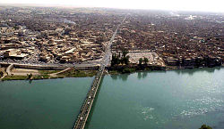
Fifth Bridge (Arabic: الجسر الخامس) is a bridge in the city of Mosul, located in the province of Nineveh Governorate in Iraq over the Tigris River. The bridge was constructed in the 1980s and links the east and west sides of the city.[1]
During the Battle of Mosul in 2016, all bridges into the city were booby trapped with explosives by ISIL, which had occupied the city since June 2014.[2] The bridge was destroyed by U.S. coalition airstrikes on 3 November 2016.[3][4][5]
See also
[edit]References
[edit]- ^ "Nineveh Bridges". ninava-explorer.com (in Arabic). Archived from the original on 5 August 2013. Retrieved 4 November 2016.
- ^ "The Daily Report - Mosul Eye, Oct. 29, 2016". Mosul Eye. 29 October 2016. Archived from the original on 1 November 2016. Retrieved 1 November 2016.
- ^ "The daily situation in Mosul – Oct. 25, 2016". Mosul Eye. 26 October 2016.
- ^ "خروج الجسر الخامس عن الخدمة في الموصل بعد قصفه من قبل التحالف الدولي" (in Arabic). Radion Awa. 3 November 2016. Retrieved 4 November 2016.
- ^ "ثاني جسر يخرج عن الخدمة بالموصل بعد تعرضه لقصف التحالف". Masr Al Arabia (in Arabic). 3 November 2016. Archived from the original on 21 December 2016. Retrieved 4 November 2016.
