
File:München - Basiskarte farbig.pdf

Size of this JPG preview of this PDF file: 730 × 599 pixels. Other resolutions: 293 × 240 pixels | 585 × 480 pixels | 936 × 768 pixels | 1,248 × 1,024 pixels | 2,495 × 2,048 pixels | 4,593 × 3,770 pixels.
Original file (4,593 × 3,770 pixels, file size: 8.06 MB, MIME type: application/pdf)
| This is a file from the Wikimedia Commons. Information from its description page there is shown below. Commons is a freely licensed media file repository. You can help. |
| Description |
English: This map of Munich was created from OpenStreetMap project data, collected by the community. This map may be incomplete, and may contain errors. Don't rely solely on it for navigation. |
| Date | see file history |
| Source | OpenStreetMap data exported an adapted by myself |
| Author | OpenStreetMap contributors |
| Permission (Reusing this file) |
All OpenStreetMap data and maps are Creative Commons "CC-BY-SA 2.0" licensed This file is licensed under the Creative Commons Attribution-Share Alike 2.0 Generic license.
|
| Other versions |
Region München:
Stadt München:
|


.png)


.png)
.png)


File history
Click on a date/time to view the file as it appeared at that time.
| Date/Time | Thumbnail | Dimensions | User | Comment | |
|---|---|---|---|---|---|
| current | 05:55, 28 May 2009 | 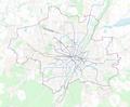 | 4,593 × 3,770 (8.06 MB) | Chumwa | Fußgängerzonen und Bahntunnel hinzugefügt |
| 21:48, 27 May 2009 | No thumbnail | 0 × 0 (8.03 MB) | Chumwa | {{Information |Description={{en|This map of Munich was created from OpenStreetMap project data, collected by the community.<br/><small>This map may be incomplete, and may contain errors. Don't rely solely on it for navigation.</small>}} |Source=[[Open |
File usage
No pages on the English Wikipedia use this file (pages on other projects are not listed).