Garki, Jigawa
Appearance
(Redirected from Garki, Nigeria)
Garki, Nigeria | |
|---|---|
LGA and town | |
| Nickname: Garkin Dirani | |
| Coordinates: 12°25′56″N 9°10′52″E / 12.4322°N 9.1812°E | |
| Country | |
| State | Jigawa State |
| Government | |
| • Local Government Chairman | Mudassir Musa (APC) |
| Time zone | UTC+1 (WAT) |
 | |
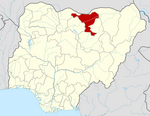
Garki is a Local Government Area of Jigawa State, Nigeria. Its headquarters are in the town of Garki. It is also called Garkin Dirani, the name of the head of the district.
It has an area of 1,408 km2 and had a population of 152,233 at the 2006 census.
The postal code of the area is 733.[1]
Garki was the site of the Garki Project, a multidisciplinary study performed by the World Health Organization from 1969 to 1976 into the effectiveness of malaria intervention techniques.[2]
Climate
[edit]The rainy season in Garki is oppressive and generally gloomy, with an average annual temperature of 60 to 104 degrees Fahrenheit. Garki has a dry season with partly cloudy and hot weather.[3][4]
References
[edit]- ^ "Post Offices- with map of LGA". NIPOST. Archived from the original on 2009-10-07. Retrieved 2009-10-20.
- ^ Molineaux, L.; Gramiccia, G. (1980). The Garki Project: Research on the Epidemiology and Control of Malaria in the Sudan Savanna of West Africa. World Health Organization. ISBN 9241560614.
- ^ "Garki Climate, Weather By Month, Average Temperature (Nigeria) - Weather Spark". weatherspark.com. Retrieved 2023-08-28.
- ^ "Garki, Jigawa, NG Climate Zone, Monthly Averages, Historical Weather Data". tcktcktck.org. Retrieved 2023-08-28.


