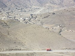
Ghulam Khan
Appearance
Ghulam Khan
غلام خان غلام خان | |
|---|---|
Town | |
 | |
| Coordinates: 33°08′38″N 70°01′26″E / 33.14389°N 70.02389°E | |
| Country | |
| Province | |
| District | North Waziristan |
| Tehsil | Ghulam Khan |
| Elevation | 2,010 m (6,590 ft) |
| Population | |
• Total | 2,553 |
| Time zone | UTC+5 (PST) |
Ghulām Khān (Pashto/Urdu: غلام خان) is a town in North Waziristan, Khyber Pakhtunkhwa, Pakistan. Ghulam Khan is on the border between Pakistan and Afghanistan.
It is the third most important border crossing point between Pakistan and Afghanistan, after Chaman and Torkham. It connects Khost, Afghanistan, to Bannu, Pakistan.
The border reopened for trade between Pakistan and Afghanistan on 9 March 2018.
North Waziristan region including this residential town, Ghulam Khan, has a total population of 543,254 per 2017 Census of Pakistan.[2]
References
[edit]- ^ "POPULATION AND HOUSEHOLD DETAIL FROM BLOCK TO DISTRICT LEVEL: FATA (NORTH WAZIRISTAN) (see page 9 of 19 for Ghulam Khan population)" (PDF). Pakistan Bureau of Statistics, Government of Pakistan website. 3 January 2018. Archived from the original (PDF) on 28 July 2018. Retrieved 25 November 2023.
- ^ "North Waziristan - former FATA (Federally Administered Tribal Areas) region, now part of Khyber Pakhtunkhwa province". Citypopulation.de website. Archived from the original on 29 April 2020. Retrieved 25 November 2023.


