Griston
| Griston | |
|---|---|
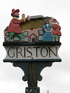
 Griston village sign | |
Location within Norfolk | |
| Area | 5.62 km2 (2.17 sq mi) |
| Population | 1,540 (2011)[1] |
| • Density | 274/km2 (710/sq mi) |
| OS grid reference | TL944994 |
| Civil parish |
|
| District | |
| Shire county | |
| Region | |
| Country | England |
| Sovereign state | United Kingdom |
| Post town | THETFORD |
| Postcode district | IP25 |
| Dialling code | 01953 |
| Police | Norfolk |
| Fire | Norfolk |
| Ambulance | East of England |
Griston is a village and civil parish in the Wayland area of the Breckland district of Norfolk, England. It covers an area of 5.62 km2 (2.17 sq mi) and had a population of 1,206 in 206 households at the 2001 census,[2] increasing to a population of 1,540 in 246 households at the 2011 Census.
It has a church dedicated to St. Peter and St. Paul, a pub (The Waggon and Horses), an elderly home (Thorp House), and a day care centre for the elderly. It hosts part of the RAF Watton wartime airfield (now belonging to the USAAF), and the Category C Wayland Prison. It lies between the town of Watton, where the nearest high school is Wayland Academy, and a fellow Wayland village of Caston, where the nearest primary school is Caston CE VA Primary School.
History of Griston
[edit]The villages name origin is uncertain possibly "Griss's farm/settlement" or perhaps "young pig farm/settlement".
The village can be traced way back to the Domesday Book.
The local Griston Hall, near Wayland Wood, is in folklore the abode of the wicked uncle who ordered the death of his wards, the Babes in the Wood, so that he could inherit their property.[3] The village sign reflects the story.
The village used to be made up of houses built for prison officers that worked at the prison.
Watton and Griston Link
[edit]As part of the Sustrans Connect2 project proposals are in place to create a cycling and walking route between Griston and the market town of Watton. The new route would follow the boundary of the Watton airfield and provide a shorter, traffic free alternative to the A1075.[4] Norfolk County Council have allocated a £40,000 contribution towards funding of the scheme.[5] A schematic map of the scheme has been published online.[6]
References
[edit]- ^ "Civil Parish population 2011". Neighbourhood Statistics. Office for National Statistics. Retrieved 5 August 2016.
- ^ Census population and household counts for unparished urban areas and all parishes. Office for National Statistics & Norfolk County Council (2001). Retrieved 20 June 2009.
- ^ "Norfolk Folk Tales – Legends said to have originated in Norfolk". Visit Breckland. Breckland District Council. Archived from the original on 4 March 2007.
- ^ "Watton and Griston Link". Sustrans. Retrieved 7 July 2009.
- ^ "Planning Obligations Monitoring Statement" (PDF). Norfolk County Council. February 2009. Retrieved 7 July 2009.
- ^ "Watton and Griston Link Schematic Map" (PDF). Sustrans. Archived from the original (PDF) on 21 October 2007. Retrieved 7 July 2009.
http://kepn.nottingham.ac.uk/map/place/Norfolk/Griston

