Hertford Lock
Appearance
| Hertford Lock | |
|---|---|
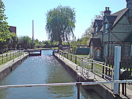
 The lock and lock-keeper's cottage | |
 | |
| 51°48′14″N 0°04′00″W / 51.803799°N 0.066739°W | |
| Waterway | River Lee Navigation |
| County | Hertfordshire |
| Maintained by | Canal & River Trust |
| Operation | Manual |
| Length | 85 feet (25.9 m) |
| Width | 16 feet (4.9 m) |
| Fall | 7 feet 11 inches (2.4 m) |
| Distance to Bow Creek | 26.3 miles (42.3 km) |
| Distance to Hertford Castle Weir | 0.8 miles (1.3 km) |
Hertford Lock (No1) is a lock situated on the River Lea on the eastern side of Hartham Common, Hertford in the English county of Hertfordshire. It is owned and managed by Canal & River Trust and is the first lock of the River Lee Navigation.

Public access
[edit]The lock is located on the River Lee Navigation towpath which forms part of the Lea Valley Walk
Public transport
[edit]
External links
[edit]
