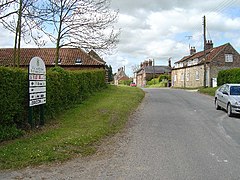
Holme on the Wolds
| Holme on the Wolds | |
|---|---|
 | |
Location within the East Riding of Yorkshire | |
| OS grid reference | SE967464 |
| • London | 165 mi (266 km) S |
| Civil parish | |
| Unitary authority | |
| Ceremonial county | |
| Region | |
| Country | England |
| Sovereign state | United Kingdom |
| Post town | BEVERLEY |
| Postcode district | HU17 |
| Dialling code | 01430 |
| Police | Humberside |
| Fire | Humberside |
| Ambulance | Yorkshire |
| UK Parliament | |
Holme on the Wolds is a village and former civil parish, now in the parish of Dalton Holme, in the East Riding of Yorkshire, England. It is situated approximately 6 miles (10 km) north-east of the market town of Market Weighton and 5.5 miles (9 km) north-west of the market town of Beverley. In 1931 the parish had a population of 132.[1] On 1 April 1935 the parish was abolished and merged with South Dalton to form "Dalton Holme".[2] It lies to west of the B1248 road.
The village forms part of and is run by the Dalton Estate, which is owned by the Hotham family.[3]
Holme on the Wolds was listed as "Hougon" in the Domesday Book. The name is believed to derive from the Old Norse word haugr meaning hills or mound.[4]
In 1823 Holme on the Wolds was a village and civil parish in the Wapentake of Harthill. Population at the time was 138, with occupations including five farmers, a boot & shoe maker, a blacksmith, and a shopkeeper.[5]
References
[edit]- ^ "Population statistics Holme on the Wolds CP/AP through time". A Vision of Britain through Time. Retrieved 8 August 2023.
- ^ "Relationships and changes Holme on the Wolds CP/AP through time". A Vision of Britain through Time. Retrieved 8 August 2023.
- ^ http://www.daltonestate.co.uk Dalton Estate
- ^ "Electronic Edition of Domesday Book - place-name forms" (PDF). Retrieved 12 November 2012.
- ^ Baines, Edward (1823): History, Directory and Gazetteer of the County of York, p. 219
- Gazetteer — A–Z of Towns Villages and Hamlets. East Riding of Yorkshire Council. 2006. p. 7.
External links
[edit] Media related to Holme on the Wolds at Wikimedia Commons
- Holme on the Wolds in the Domesday Book

