
Isparta
This article needs additional citations for verification. (November 2007) |
Isparta | |
|---|---|
 Isparta seen from a mountain | |
|
Logo | |
 Isparta Location in Turkey | |
| Coordinates: 37°45′53″N 30°33′24″E / 37.76472°N 30.55667°E | |
| Country | Turkey |
| Province | Isparta |
| District | Isparta |
| Government | |
| • Mayor | Şükrü Başdeğirmen (AKP) |
| Elevation | 1,035 m (3,396 ft) |
| Population (2022)[1] | 247,580 |
| Time zone | UTC+3 (TRT) |
| Postal code | 32000 |
| Area code | 0246 |
| Website | www |
Isparta is a city in western Turkey. It is the seat of Isparta Province and Isparta District.[2] Its population is 247,580 (2022).[1] Its elevation is 1035 m. It is known as the "City of Roses". Isparta is well-connected to other parts of Turkey via roads. Antalya lies 130 km to the south and Eskişehir is 350 km to the north. Süleyman Demirel University has introduced thousands of youths from varied backgrounds to the city's mostly conservative fabric in recent years. The city's football team, Ispartaspor, plays in Group 7 of the Turkish Regional Amateur League.
History
[edit]
Roman era
[edit]Isparta is a Turkish spelling of Greek Sparta, by prothesis declustering.[3] Isparta was said to correspond to the ancient city of Baris, which is a namesake and was part of the Roman province of Pisidia.[4] A later theory has it instead as the Eastern Roman fortress Saporda; in Muslim sources it appears as Sabarta.[5] GE Bean characterized the situation thus: "These perpetually shifting conceptions leave the reader quite bewildered."[6] Modern scholars locate Baris near Kılıç, in Keçiborlu district, Isparta province.[7][8] At an early stage it became a Christian bishopric, a suffragan of the Metropolitan see of Antioch of Pisidia, the capital of the province. The names of two of its bishops are known with certainty: Heraclius participated in the First Council of Nicaea in 325 and Leo in the Second Council of Nicaea in 787. In addition, Paulus was at the Council of Constantinople (869) and Stephanus was at the Council of Constantinople (879), but one or both of these may have been of the Baris in the Roman province of Hellespontus.[9][10] Like most sees in Asia Minor, it faded away.
- 1071: Conquered by the Seljuk Turks.
- Late 13th century: Becomes part of the Hamidids.
- 1381: Isparta is sold to the Ottoman sultan Murad I by the Hamidid Emir.
- Late 19th century: Muslim refugees from the Balkans settle around Isparta. The Bulgarian refugees brought the knowledge of kazanlik rosewater production with them, leading to Isparta's nickname: city of roses.
- 1914: According to the 1914 Ottoman population statistics, the district of Isparta had a total population of 54.465, consisting of 46.698 Muslims, 6.648 Greeks and 1.119 Armenians.[11]
- 1923: The Greek inhabitants of the area were forced to move to Greece under the Greco-Turkish population exchange.
Notable flight crashes
[edit]On 19 September 1976, Turkish Airlines Flight 452, a Boeing 727 aircraft, crashed on a hill in Isparta, also known Mount Karatepe, killing all 154 passengers and crew. On 30 November 2007, Atlasjet Flight 4203 crashed on approach to Isparta Süleyman Demirel Airport, killing all 57 passengers and crew.
Titular see
[edit]No longer a residential bishopric, 'Baris in Pisidia' is today listed by the Catholic Church as a titular bishopric, nominal suffragan of Nicomedia,[12] since the diocese was nominally restored in 1933: Latin adjective Baren(us) in Pisidia (Latin). It has been vacant for decades, having had the following incumbents, so far of the fitting Episcopal (lowest) rank:[13]
- Alfred Bertram Leverman (1948.04.24 – 1953.07.27) as Auxiliary Bishop of Halifax (Canada) (1948.04.24 – 1953.07.27); later Bishop of Saint John, New Brunswick (Canada) (1953.07.27 – 1968.09.07), emeritate as Titular Bishop of Altava (1968.09.07 – death 1972.04.28)
- José de Almeida Batista Pereira (1953.12.22 – 1955.11.07) as Auxiliary Bishop of Niterói (Brazil) (1953.12.22 – 1955.11.07), Bishop of Sete Lagoas (Brazil) (1955.11.07 – 1964.04.02), Bishop of Guaxupé (Brazil) (1964.04.02 – retired 1976.01.16); died 2009
- António Cardoso Cunha (1956.03.09 – 1967.01.10), first as Auxiliary Bishop of Beja (Portugal) (1956.03.09 – 1965), then as Coadjutor Bishop of Vila Real (Portugal) (1965 – 1967.01.10), next succeeded as Bishop of Vila Real (1967.01.10 – retired 1991.01.19), died 2004.
Economy
[edit]
The main economic activities of Isparta are the production of rosewater and handmade carpets. Tourism, both local and increasingly international due to "biblical tourism", is becoming an important source of revenue. In the early 20th century, carpetmaking was a major industry in Isparta.[14]
Climate
[edit]Isparta has a Hot-summer Mediterranean climate (Köppen climate classification: Csa), or a temperate continental climate (Trewartha climate classification: Dc). Winters are chilly, rainy and often snowy, summers are hot and dry. The lakes around the city have an important moderating influence on the climate. Precipitation occurs mostly in the winter months, with a notable decrease in summer.
| Climate data for Isparta (1991–2020, extremes 1929–2023) | |||||||||||||
|---|---|---|---|---|---|---|---|---|---|---|---|---|---|
| Month | Jan | Feb | Mar | Apr | May | Jun | Jul | Aug | Sep | Oct | Nov | Dec | Year |
| Record high °C (°F) | 17.6 (63.7) |
22.5 (72.5) |
26.8 (80.2) |
29.5 (85.1) |
35.4 (95.7) |
36.2 (97.2) |
39.2 (102.6) |
40.3 (104.5) |
37.4 (99.3) |
33.5 (92.3) |
25.4 (77.7) |
20.0 (68.0) |
40.3 (104.5) |
| Mean daily maximum °C (°F) | 6.6 (43.9) |
8.4 (47.1) |
12.3 (54.1) |
17.0 (62.6) |
22.3 (72.1) |
27.3 (81.1) |
31.2 (88.2) |
31.4 (88.5) |
27.2 (81.0) |
21.2 (70.2) |
14.4 (57.9) |
8.5 (47.3) |
19.0 (66.2) |
| Daily mean °C (°F) | 1.8 (35.2) |
3.3 (37.9) |
6.6 (43.9) |
10.8 (51.4) |
15.6 (60.1) |
20.3 (68.5) |
24.0 (75.2) |
23.9 (75.0) |
19.3 (66.7) |
13.8 (56.8) |
7.7 (45.9) |
3.5 (38.3) |
12.5 (54.5) |
| Mean daily minimum °C (°F) | −2.1 (28.2) |
−1.1 (30.0) |
1.3 (34.3) |
4.8 (40.6) |
8.9 (48.0) |
13.0 (55.4) |
16.2 (61.2) |
16.0 (60.8) |
11.5 (52.7) |
7.2 (45.0) |
2.2 (36.0) |
−0.5 (31.1) |
6.5 (43.7) |
| Record low °C (°F) | −19.2 (−2.6) |
−21.0 (−5.8) |
−18.5 (−1.3) |
−7.7 (18.1) |
−1.2 (29.8) |
4.3 (39.7) |
4.9 (40.8) |
7.0 (44.6) |
−0.8 (30.6) |
−4.2 (24.4) |
−11.5 (11.3) |
−15.4 (4.3) |
−21.0 (−5.8) |
| Average precipitation mm (inches) | 70.3 (2.77) |
51.5 (2.03) |
55.2 (2.17) |
51.6 (2.03) |
60.1 (2.37) |
30.9 (1.22) |
19.3 (0.76) |
16.1 (0.63) |
20.8 (0.82) |
38.5 (1.52) |
43.6 (1.72) |
68.4 (2.69) |
526.3 (20.72) |
| Average precipitation days | 12.17 | 10.97 | 11.10 | 11.60 | 12.20 | 7.60 | 3.83 | 4.10 | 4.93 | 7.27 | 7.73 | 11.63 | 105.1 |
| Average snowy days | 5.5 | 5 | 2.75 | 0.5 | 0 | 0 | 0 | 0 | 0 | 0 | 0.54 | 2.5 | 16.79 |
| Average relative humidity (%) | 73.8 | 69.7 | 65 | 62 | 60.6 | 54.4 | 47.3 | 48.9 | 53.7 | 63.1 | 68.5 | 74.8 | 61.8 |
| Mean monthly sunshine hours | 114.7 | 135.6 | 179.8 | 204.0 | 251.1 | 297.0 | 334.8 | 316.2 | 273.0 | 217.0 | 165.0 | 111.6 | 2,599.8 |
| Mean daily sunshine hours | 3.7 | 4.8 | 5.8 | 6.8 | 8.1 | 9.9 | 10.8 | 10.2 | 9.1 | 7.0 | 5.5 | 3.6 | 7.1 |
| Source 1: Turkish State Meteorological Service[15][16] | |||||||||||||
| Source 2: NOAA(humidity),[17] Meteomanz(snow days 2000-2023)[18] | |||||||||||||
Sights
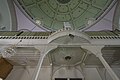
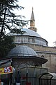
[edit]The city lies close to a fault line and is thus prone to violent earthquakes. Most of the ancient city was destroyed by an earthquake 1914. So there are only a few historical buildings left. The oldest building is the Kutlu Bey Mosque (or Ulu Camii, which means great Mosque), built in 1429 by Kutlu Bey, a general of Sultan Murad II. It was very badly destroyed by the earthquake 1914, but restored 1922. Famous is the Firdevs-Bey-Camii (Mosque) (also: Firdevs Paşa Camii, Mimar Sinan Camii) from 1561. The mosque and the neighboring Bedesten (market hall) are attributed to the architect Sinan. Badly damaged by earthquake in 1914, it was renovated afterwards. Most of the churches have been destroyed, only a few remain, especially the Aya Payana Church (Turkish: Aya Baniya Kilisesi); a Greek-Orthodox church from 1750. In a state of ruin since 1923, the roof was re-covered in 1999. Another renovation is planned but has not yet been carried out (as of 2022)
-
 Isparta Iplik Camii
 -
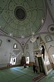 Isparta Mimar Sinan (Firdevs Paşa) Cami
 -
 Isparta Mimar Sinan (Firdevs Paşa) Cami
 -
 Isparta; Firdevs Paşa Camiye von Süd
 -
 Isparta Kutlu Bey Camii aka Ulu Camii
 -
 Isparta Kutlu Bey Camii aka Ulu Camii
 -
 Isparta Kutlu Bey Camii aka Ulu Camii

_Cami_2435.jpg)
_Cami_2437.jpg)


The city also has a museum.
-
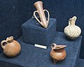 Isparta museum Early Bronze Age vessels
 -
 Isparta museum Late Archaic stele
 -
 Isparta museum Late Archaic steles
 -
 Isparta museum Eğirdir treasure
 -
 Isparta museum Anatolian dresses
 -
 Isparta museum church bell


Other sights include:
-
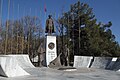 Isparta Atatürk monument
 -
 Süleyman Demirel Heykeli
 -
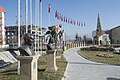 Isparta Şehitler Parkı
 -
 Isparta Clocktower
 -
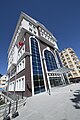 Isparta Culture and Tourism building
 -
 Isparta Provincial Directorate of National Education
 -
 Isparta Firdevs Bey Bedesteni


Notable people
[edit]- Aylin Cesur, doctor and politician
- Erkan Mumcu, politician and the former of Minister of National Education, Minister of Culture and Tourism (Turkey)
- Süleyman Demirel, former prime minister of Turkey and president of Turkey, was born in the village of Islamköy close to Isparta
- Cahit Berkay, musician
Mayors of Isparta
[edit]- 1984-1980 Dogan Kımıllı AP[19]
- 1980-1984 Müslim Sevgi[19]
- 1984-1989 Ziya Zeynelgil ANAP
- 1989-1994 Altan Raşit Civan DYP, Refah Party
- 1994-1999 Mehmet Aybatılı DYP
- 1999-2004 and 2009-2019 Yusuf Ziya Günaydın MHP
- 2004-2009 Hasan Balaman AK Party
- 2019-present Şükrü Başdeğirmen AK Party
Twin towns – sister cities
[edit]Isparta is twinned with:
See also
[edit]References
[edit]- ^ a b "Address-based population registration system (ADNKS) results dated 31 December 2022, Favorite Reports" (XLS). TÜİK. Retrieved 13 March 2023.
- ^ İl Belediyesi, Turkey Civil Administration Departments Inventory. Retrieved 1 March 2023.
- ^ Studies in Etymology and Etiology: With Emphasis on Germanic, Jewish, Romance and Slavic Languages, page 316, by David L. Gold
- ^ Encyclopaedia of Islam, First Edition (1913-1936), section "Isparta", Mordtmann, J. H.
- ^ Encyclopaedia of Islam, Second Edition, section "Isparta", Flemming, B.
- ^ Anatolian Studies. Volume 9. 1959. Notes and Inscriptions from Pisidia, Part 1, page 74, by G. E. Bean
- ^ Richard Talbert, ed. (2000). Barrington Atlas of the Greek and Roman World. Princeton University Press. p. 65, and directory notes accompanying. ISBN 978-0-691-03169-9.
- ^ Lund University. Digital Atlas of the Roman Empire.
- ^ Michel Lequien, Oriens christianus in quatuor Patriarchatus digestus, Paris 1740, Vol. I, coll. 1049–1050
- ^ Raymond Janin, v. 2. Baris, in Dictionnaire d'Histoire et de Géographie ecclésiastiques, vol. VI, 1932, col. 808
- ^ Kemal Karpat (1985), Ottoman Population, 1830-1914, Demographic and Social Characteristics, The University of Wisconsin Press, p. 180-181
- ^ Annuario Pontificio 2013 (Libreria Editrice Vaticana 2013 ISBN 978-88-209-9070-1), p. 847
- ^ http://www.gcatholic.org/dioceses/former/t0281.htm GCatholic
- ^ Prothero, G. W. (1920). Anatolia. London: H.M. Stationery Office. p. 110.
- ^ "Resmi İstatistikler: İllerimize Ait Mevism Normalleri (1991–2020)" (in Turkish). Turkish State Meteorological Service. Retrieved 28 June 2021.
- ^ "İllerimize Ait Genel İstatistik Verileri" [General statistical data for provinces]. mgm.gov.tr (in Turkish). Meteoroloji Genel Müdürlüğü. Retrieved 8 April 2024.
- ^ "WMO Climate Normals for 1991-2020: Isparta" (CSV). National oceanic and atmospheric administration. Retrieved 8 April 2024.
- ^ "Isparta - Weather data by months". meteomanz. Retrieved 17 July 2024.
- ^ a b "BAŞKANLARIMIZ". www.isparta.bel.tr (in Turkish).
- ^ "خواهرهای ناتنی "همدان" را فراموش کردهاند؟". isna.ir (in Persian). Iranian Students' News Agency. 13 October 2019. Retrieved 19 June 2020.
Sources and external links
[edit]- Hunt for clues in Turkish crash
- Isparta City Portal – All about Isparta
- GCatholic – (titular) bishopric
- Isparta Son Dakika
| Municipalities | |
|---|---|
| Villages |
|
| International | |
|---|---|
| National | |