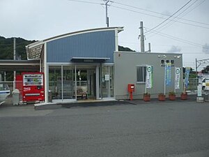
Kōzaki Station (Ōita)
 Kōzaki Station in 2009 | |||||||||||
| General information | |||||||||||
| Location | Honkozaki 260, Ōita-shi, Ōita-ken, 879-2111 Japan | ||||||||||
| Coordinates | 33°14′02″N 131°47′43″E / 33.23389°N 131.79528°E | ||||||||||
| Operated by | |||||||||||
| Line(s) | ■ Nippō Main Line | ||||||||||
| Distance | 151.8 km from Kokura | ||||||||||
| Platforms | 1 side + 1 island platforms | ||||||||||
| Tracks | 3 (1 is a siding) + several other sidings | ||||||||||
| Construction | |||||||||||
| Structure type | At grade | ||||||||||
| Parking | Available | ||||||||||
| Bicycle facilities | Designated parking area for bikes | ||||||||||
| Accessible | No - platforms accessed by footbridge | ||||||||||
| Other information | |||||||||||
| Status | Unstaffed | ||||||||||
| Website | Official website | ||||||||||
| History | |||||||||||
| Opened | 1 April 1914 | ||||||||||
| Passengers | |||||||||||
| FY2015 | 349 daily | ||||||||||
| Services | |||||||||||
| |||||||||||
| |||||||||||
Kōzaki Station (幸崎駅, Kōzaki-eki) is a passenger railway station located in Ōita City, Ōita Prefecture, Japan. It is operated by JR Kyushu. The station serves the Ōita suburb of Sakanoichi.[1][2]
Lines
[edit]The station is served by the Nippō Main Line and is located 151.8 km from the starting point of the line at Kokura.[3]
Layout
[edit]The station consists of an island platform and a side platform serving three tracks at grade. Platforms/tracks 1 and 2 are located on the island while platform 3 is a side platform served by track 3 which is a siding. The station building, a modern structure completed in 2009, is located next to the tracks nearest track 1 and not in contact with any platform. It houses a waiting area, an automatic ticket vending machine, a SUGOCA card reader and a ticket window (which is, at present, not staffed). Access from the station building to the platforms is by means of a footbridge. Several sidings also run in between track 1 and the station building.[2][3][4]
Platforms
[edit]| 1 | ■ ■ Nippō Main Line | for Saiki and Nobeoka |
| 2, 3 | ■ ■ Nippō Main Line | for Ōita and Beppu |
-
A view of the platforms and tracks. The train is standing on track 3 which is a siding. To the right, some sidings can be seen between the island platform and the station building.
-
The old station building. This photo was taken in 2005.
History
[edit]The private Kyushu Railway had, by 1909, through acquisition and its own expansion, established a track from Kokura to Yanagigaura. The Kyushu Railway was nationalised on 1 July 1907. Japanese Government Railways (JGR), designated the track as the Hōshū Main Line on 12 October 1909 and expanded it southwards in phases, with Kōzaki opening as the new southern terminus on 1 April 1914. It became a through-station on 15 August 1915 when the track was extended further south to Usuki. On 15 December 1923, the Hōshū Main Line was renamed the Nippō Main Line. With the privatization of Japanese National Railways (JNR), the successor of JGR, on 1 April 1987, the station came under the control of JR Kyushu.[5][6]
JR Kyushu stopped staffing Kōzaki in 2016 because of declining passenger traffic.[7] However, on 17 March 2018, "Smart Support" facilities were added to the station. Under this scheme, although there would not be railway personnel in attendance, passengers could receive assistance via intercom from staff at a central support centre.[8]
Passenger statistics
[edit]In fiscal 2015, there were a total of 127,334 boarding passengers, giving a daily average of 349 passengers.[9]
Surrounding area
[edit]See also
[edit]References
[edit]- ^ "JR Kyushu Route Map" (PDF). JR Kyushu. Retrieved 23 February 2018.
- ^ a b "幸崎" [Kōzaki]. hacchi-no-he.net. Retrieved 18 June 2018.
- ^ a b Kawashima, Ryōzō (2013). 図説: 日本の鉄道 四国・九州ライン 全線・全駅・全配線・第6巻 熊本 大分 エリア [Japan Railways Illustrated. Shikoku and Kyushu. All lines, all stations, all track layouts. Volume 6 Kumamoto Ōita Area] (in Japanese). Kodansha. pp. 44, 82. ISBN 9784062951654.
- ^ "日豊本線 幸崎駅" [Nippō Main Line Kōzaki]. Association of Railway Architects website. Retrieved 19 June 2018. Website with good photographic coverage of station facilities.
- ^ Ishino, Tetsu; et al., eds. (1998). 停車場変遷大事典 国鉄・JR編 [Station Transition Directory – JNR/JR] (in Japanese). Vol. I. Tokyo: JTB Corporation. pp. 228–9. ISBN 4-533-02980-9.
- ^ Ishino, Tetsu; et al., eds. (1998). 停車場変遷大事典 国鉄・JR編 [Station Transition Directory – JNR/JR] (in Japanese). Vol. II. Tokyo: JTB Corporation. p. 754. ISBN 4-533-02980-9.
- ^ "駅営業体制の見直しについて" [Revision of station business system] (PDF). JR Kyushu. 25 February 2016. Archived from the original (PDF) on 5 March 2016. Retrieved 19 June 2018.
- ^ "大分市内の一部の駅が「Smart Support Station」に変わります" [Some stations in Ōita City to become "Smart Support Stations"] (PDF). JR Kyushu. 16 February 2018. Retrieved 19 June 2018.
- ^ "平成28年版 大分県統計年鑑 11 運輸および通信" [Oita Prefecture Statistics Yearbook 2016 Edition Section 11 Transportation and Communications]. Oita Prefectural Government website. Retrieved 19 June 2018. See table 128 Transport situation by individual railway stations (JR Kyushu JR Freight).
External links
[edit]![]() Media related to Kōzaki Station (Oita) at Wikimedia Commons
Media related to Kōzaki Station (Oita) at Wikimedia Commons
- Kōzaki (JR Kyushu)(in Japanese)


