Kaldygaity
| Kaldygaity Қалдығайты | |
|---|---|
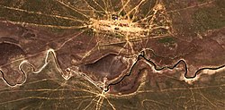
 The Kaldygaity meandering westwards south of Ushana village Sentinel-2 image | |
| Location | |
| Countries | Kazakhstan |
| Physical characteristics | |
| Source | Mt Almastau |
| • coordinates | 50°09′14″N 54°21′07″E / 50.15389°N 54.35194°E |
| • elevation | ca 200 m (660 ft) |
| Mouth | lakes near Tolen |
• coordinates | 49°26′07″N 52°42′00″E / 49.43528°N 52.70000°E |
• elevation | 8 m (26 ft) |
| Length | 243 km (151 mi) |
| Basin size | 5,800 km2 (2,200 sq mi) |
The Kaldygaity (Kazakh: Қалдығайты; Russian: Калдыгайты) is a river in the West Kazakhstan Region, Kazakhstan. It is 243 kilometres (151 mi) long and has a catchment area of 5,800 square kilometres (2,200 sq mi).[1]
The Kaldygaity belongs to the Ural basin. The banks of the river are a seasonal grazing ground for local cattle.[2]
Course
[edit]The Kaldygaity has its sources in the southwestern slopes of Mount Almastau.[3] It heads first southwestwards across Shyngyrlau District, then it bends westwards and flows in that direction through Karatobe District. It forms meanders in a floodplain until it meets the wide salt lake area that lies near Tolen village. The Buldyrty (Бұлдырты) river flows parallel to the Kaldygaity roughly 45 kilometres (28 mi) to the northwest.[4][5]
The Kaldygaity has 40 tributaries that are longer than 10 kilometres (6.2 mi). The main ones are the Peschanaya, Bayanas and Ashchysay. The river valley is wide and in its middle and lower course the Kaldygaity flows across sandy terrain. It is fed by snow and rain. On years of heavy snow its lower stretch floods.[1]
 |
Fauna
[edit]The main fish species in the Kaldygaity include pike, Eurasian carp, perch and karabalik. The European pond turtle is also found in the river.[6] The reed undergrowth of the lower reaches of the Kaldygaity and neighboring Olenti provides a habitat and a mass-breeding place for the Asian locust.[7]
See also
[edit]References
[edit]- ^ a b Kazakhstan National encyclopedia, volume VIII / Chief editor A. Nysanbayev - Almaty "Kazakh encyclopedia" General editor, 1998 ISBN 5-89800-123-9
- ^ Determination of the Degradation Degree of Pasture Lands in the West Kazakhstan Region Based on Monitoring Using Geoinformation Technologies
- ^ "M-40 Topographic Chart (in Russian)". Retrieved 23 February 2023.
- ^ "M-39 Topographic Chart (in Russian)". Retrieved 23 February 2023.
- ^ Google Earth
- ^ Nature of the Republic of Kazakhstan, volume 3, part 2
- ^ OTS. Issues 75-52006, United States Department of Commerce. Office of Technical Services. p. 118
External links
[edit] Media related to Kaldygaity at Wikimedia Commons
- Rivers of the West Kazakhstan region.

