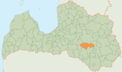
Krustpils Municipality
Appearance
Krustpils Municipality
Krustpils novads | |
|---|---|
 | |
| Country | |
| Formed | 2021 |
| Centre | Jēkabpils (extraterritorially) |
| Government | |
| • Chairman | Kārlis Pabērzs (V) |
| Area | |
| • Total | 811.73 km2 (313.41 sq mi) |
| • Land | 789.49 km2 (304.82 sq mi) |
| • Water | 22.24 km2 (8.59 sq mi) |
| Population (2021)[2] | |
| • Total | 5,461 |
| • Density | 6.7/km2 (17/sq mi) |
| Website | www |
Krustpils Municipality (Latvian: Krustpils novads) is a former municipality in Latgale, Latvia. The municipality was formed in 2009 by merging Atašiene parish, Krustpils parish, Kūkas parish, Mežāre parish, Varieši parish and Vīpe parish. The administrative centre was located in Jēkabpils city, which was not included in the territory of the municipality.
Parts of Teiči Nature Reserve were located in Krustpils Municipality.
On 1 July 2021, Krustpils Municipality ceased to exist and its territory was merged into Jēkabpils Municipality.[3]
See also[edit]
References[edit]
- ^ Central Statistical Bureau of Latvia https://data.stat.gov.lv/pxweb/lv/OSP_PUB/START__ENV__DR__DRT/DRT010/. Retrieved 25 February 2021.
{{cite web}}: Missing or empty|title=(help) - ^ Central Statistical Bureau of Latvia https://data.stat.gov.lv/pxweb/lv/OSP_PUB/START__POP__IR__IRS/IRD060/. Retrieved 15 June 2021.
{{cite web}}: Missing or empty|title=(help) - ^ [1] Law on Administrative Territories and Populated Areas
56°30′N 25°51′E / 56.500°N 25.850°E


