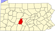
Lakemont, Pennsylvania
Appearance
Lakemont, Pennsylvania | |
|---|---|
| Coordinates: 40°27′51″N 78°23′32″W / 40.46417°N 78.39222°W | |
| Country | United States |
| State | Pennsylvania |
| County | Blair |
| Townships | Logan, Allegheny |
| Area | |
• Total | 1.04 sq mi (2.68 km2) |
| • Land | 1.01 sq mi (2.63 km2) |
| • Water | 0.02 sq mi (0.06 km2) |
| Elevation | 1,066 ft (325 m) |
| Population | |
• Total | 1,773 |
| • Density | 1,748.52/sq mi (675.30/km2) |
| Time zone | UTC-5 (Eastern (EST)) |
| • Summer (DST) | UTC-4 (EDT) |
| FIPS code | 42-40992 |
| GNIS feature ID | 2628809[2] |
Lakemont is a census-designated place[4] in Allegheny and Logan Townships in Blair County, Pennsylvania, United States. It is located to the east of I-99 and is located between Altoona and Hollidaysburg. Lakemont is the location of Lakemont Park,[5] although the address is generally Altoona and part of the "Lakemont" area actually lies within the Altoona city boundaries. As of the 2010 census, the population was 1,868 residents.[6]
Demographics
[edit]| Census | Pop. | Note | %± |
|---|---|---|---|
| 2020 | 1,773 | — | |
| U.S. Decennial Census[7] | |||
Education
[edit]The school district for most of the CDP is Altoona Area School District.[8] Altoona Area High School is the comprehensive high school for that district.
A portion of the CDP is in Hollidaysburg Area School District.[8]
References
[edit]- ^ "ArcGIS REST Services Directory". United States Census Bureau. Retrieved October 12, 2022.
- ^ a b U.S. Geological Survey Geographic Names Information System: Lakemont, Pennsylvania
- ^ "Census Population API". United States Census Bureau. Retrieved October 12, 2022.
- ^ "2010 Census". www.census.gov. Retrieved September 2, 2016.
- ^ "Lakemont Park & The Island Water Park". www.lakemontparkfun.com. Retrieved September 2, 2016.
- ^ "U.S. Census website". United States Census Bureau. Retrieved May 14, 2011.
- ^ "Census of Population and Housing". Census.gov. Retrieved June 4, 2016.
- ^ a b "2020 CENSUS - SCHOOL DISTRICT REFERENCE MAP: Blair County, PA" (PDF). U.S. Census Bureau. Retrieved December 22, 2024. - Text list
External links
[edit]


