Lewis Channel
Appearance
| Lewis Channel | |
|---|---|
 Lewis Channel | |
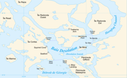
 Lewis Channel is located between Cortes Island and West Redonda Island | |
| Location | Discovery Islands, British Columbia |
| Coordinates | 50°11′00″N 124°55′25″W / 50.18333°N 124.92361°W |
| Type | Strait |
| Ocean/sea sources | Salish Sea |
| References | [1] |
Lewis Channel[1] is a strait located between Cortes Island and West Redonda Island in the Discovery Islands of British Columbia, Canada. It is part of the northern Salish Sea.
Geography
[edit]Lewis Channel connects Desolation Sound to the south with Calm Channel and Deer Channel to the north. Teakerne Arm branches off of the main channel to the east and forms a large protected bay within West Redonda Island. The channel itself contains no major islands.
Hydrology
[edit]The northern hydrological limit of Lewis Channel delineates part of the northern limit of the Salish Sea.[2]
See also
[edit]References
[edit]- ^ a b "BC Geographical Names". apps.gov.bc.ca. Retrieved 2020-09-29.
- ^ Environmental History and Features of Puget Sound Archived 2009-05-13 at the Wayback Machine, NOAA-NWFSC

