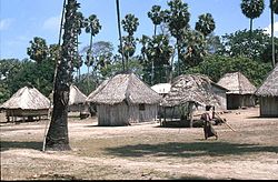
Loré Administrative Post
Appearance
You can help expand this article with text translated from the corresponding article in German. (August 2022) Click [show] for important translation instructions.
|
Loré | |
|---|---|
| |
 Loré village | |
 Official map of the Lospalos Administrative Post (2015–2021), from which Loré was separated | |
| Coordinates: 8°39′S 127°1′E / 8.650°S 127.017°E | |
| Country | |
| Municipality | Lautém |
| Established | 1 January 2022 |
| Seat | Loré |
| Sucos |
|
| Area | |
• Total | 179.79 km2 (69.42 sq mi) |
| Population (2022) | |
• Total | 3,692 |
| • Density | 21/km2 (53/sq mi) |
| Time zone | UTC+09:00 (TLT) |
Loré, officially Loré Administrative Post (Portuguese: Posto Administrativo de Loré, Tetum: Postu administrativu Loré), is an administrative post in Lautém municipality, East Timor. It was separated from Lospalos Administrative Post with effect from 1 January 2022.[1]
References
[edit]- ^ Soares Martins, Evaristo (31 May 2022). "Parlamento Nacional aprova propostade lei da divisão administrativa do territorio na final global" [National Parliament globally finally approves proposal for a law on the administrative division of the territory] (in Portuguese). Tatoli. Archived from the original on 14 August 2021. Retrieved 31 August 2022.

