Métropole Rouen Normandie
Métropole Rouen Normandie | |
|---|---|
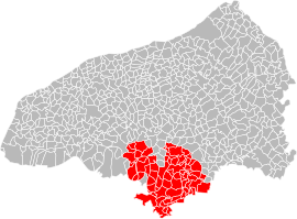
 Situation of the metropolis in Seine-Maritime. | |
| Country | France |
| Region | Normandy |
| Department | Seine-Maritime |
| No. of communes | 71 |
| Established | 2015 |
| Seat | Rouen |
| Government | |
| • President (2020–2026) | Nicolas Mayer-Rossignol (PS) |
Area | 663.8 km2 (256.3 sq mi) |
| Population (2018) | 492,681 |
| • Density | 742/km2 (1,920/sq mi) |
| Website | www |
Métropole Rouen Normandie (French pronunciation: [metʁɔpɔl ʁwɑ̃ nɔʁmɑ̃di]) is the métropole, an intercommunal structure, centred on the city of Rouen. It is located in the Seine-Maritime department, in the Normandy region, north-western France. It was created in January 2015, replacing the previous Communauté d'agglomération Rouen-Elbeuf-Austreberthe.[1] Its area is 663.8 km2. Its population was 492,681 in 2014, of which 111,360 in Rouen proper.[2]
History
[edit]The Agglomeration community of Rouen-Elbeuf-Austreberthe (French: Communauté d'agglomération Rouen-Elbeuf-Austreberthe) was created in 2010. On January 1, 2015, the Metropolis replaced the agglomeration community in accordance with a law of January 2014.[3]
Responsibilities
[edit]The goal of the Métropole is to build a better metropolitan area by synchronizing the transport system, environmental actions, etc.
Communes
[edit]The 71 communes of the Métropole Rouen Normandie are:[1][4][5]
- Amfreville-la-Mi-Voie
- Anneville-Ambourville
- Les Authieux-sur-le-Port-Saint-Ouen
- Bardouville
- Belbeuf
- Berville-sur-Seine
- Bihorel
- Bois-Guillaume
- Bonsecours
- Boos
- La Bouille
- Canteleu
- Caudebec-lès-Elbeuf
- Cléon
- Darnétal
- Déville-lès-Rouen
- Duclair
- Elbeuf
- Épinay-sur-Duclair
- Fontaine-sous-Préaux
- Franqueville-Saint-Pierre
- Freneuse
- Gouy
- Grand-Couronne
- Le Grand-Quevilly
- Hautot-sur-Seine
- Hénouville
- Le Houlme
- Houppeville
- Isneauville
- Jumièges
- La Londe
- Malaunay
- Maromme
- Le Mesnil-Esnard
- Le Mesnil-sous-Jumièges
- Montmain
- Mont-Saint-Aignan
- Moulineaux
- La Neuville-Chant-d'Oisel
- Notre-Dame-de-Bondeville
- Oissel
- Orival
- Petit-Couronne
- Le Petit-Quevilly
- Quevillon
- Quévreville-la-Poterie
- Roncherolles-sur-le-Vivier
- Rouen
- Sahurs
- Saint-Aubin-Celloville
- Saint-Aubin-Épinay
- Saint-Aubin-lès-Elbeuf
- Sainte-Marguerite-sur-Duclair
- Saint-Étienne-du-Rouvray
- Saint-Jacques-sur-Darnétal
- Saint-Léger-du-Bourg-Denis
- Saint-Martin-de-Boscherville
- Saint-Martin-du-Vivier
- Saint-Paër
- Saint-Pierre-de-Manneville
- Saint-Pierre-de-Varengeville
- Saint-Pierre-lès-Elbeuf
- Sotteville-lès-Rouen
- Sotteville-sous-le-Val
- Tourville-la-Rivière
- Le Trait
- Val-de-la-Haye
- Yainville
- Ymare
- Yville-sur-Seine
See also
[edit]References
[edit]- ^ a b "Décret n° 2014-1604 du 23 décembre 2014 portant création de la métropole dénommée « Métropole Rouen Normandie » | Legifrance". Retrieved 2017-06-29.
- ^ Comparateur de territoire, INSEE. 4 April 2022.
- ^ (in French) Loi n° 2014-58 du 27 janvier 2014 de modernisation de l'action publique territoriale et d'affirmation des métropoles
- ^ Métropole Rouen Normandie (N° SIREN : 200023414), BANATIC. Accessed 17 October 2024.
- ^ INSEE
49°26′N 1°05′E / 49.44°N 1.09°E
